New High Resolution Map Reveals Massive Hidden Groundwater Reserves Beneath The United States
New research reveals US groundwater reserves reach 306,500 cubic kilometers, significantly surpassing previous estimates based on surface water data.
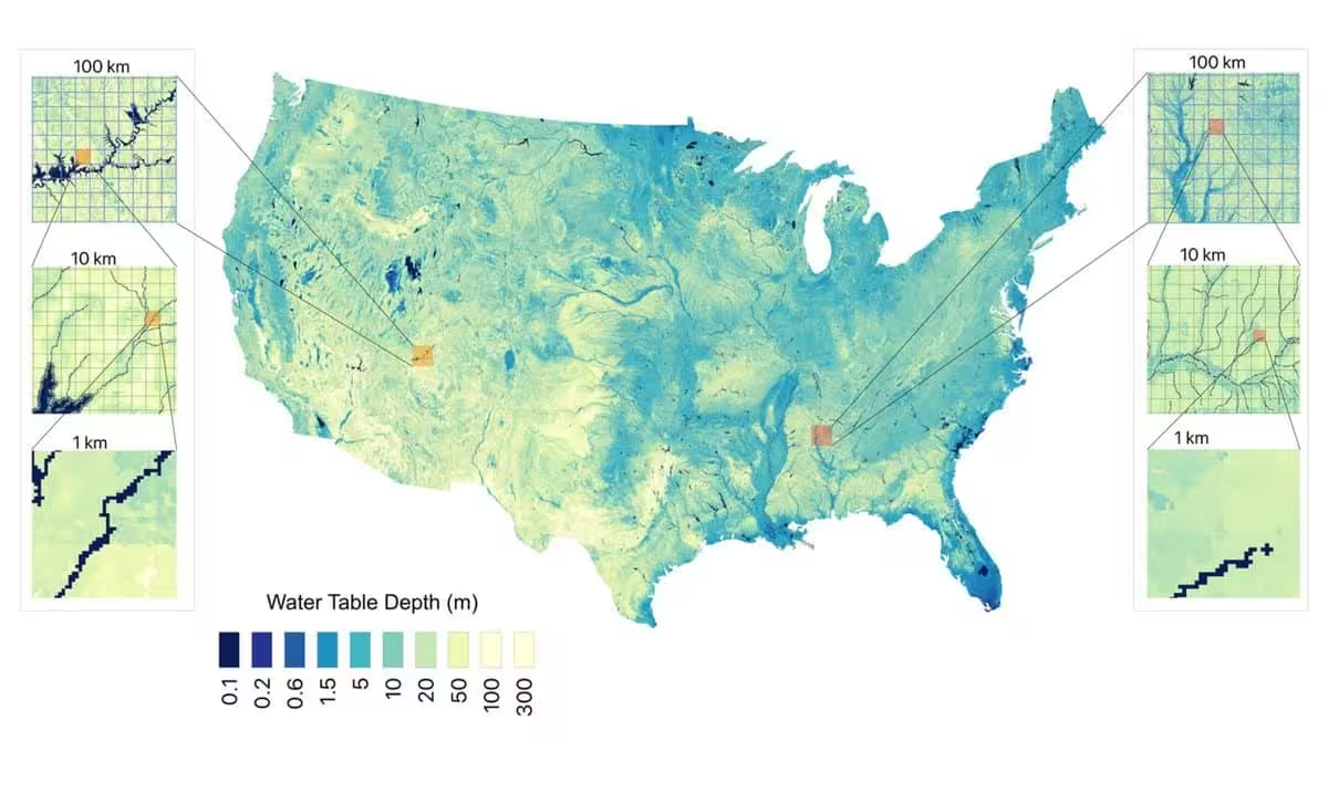
Researchers have developed a groundbreaking high-resolution map of groundwater across the contiguous United States, offering a significantly clearer picture of the nation’s hidden water resources. By integrating nearly one million observational data points with satellite imagery and machine learning, the team has achieved a 30-meter resolution, vastly improving upon the coarse estimates that have historically hampered water management efforts.
Measuring groundwater has long been a challenge because these vast reserves remain largely out of sight. While surface water monitoring is straightforward, groundwater accessibility depends on complex geological factors like soil porosity and the specific depth of the water table. Princeton University hydrologist Reed Maxwell notes that this lack of visibility is akin to having a savings account with no way of knowing the current balance or how much is being deposited over time.
Revealing a Larger Hidden Reservoir
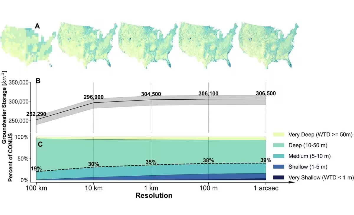
The study estimates that approximately 306,500 cubic kilometers of groundwater exist beneath the contiguous United States, down to a depth of 392 meters. This figure sits within the range of previous estimates, which fluctuated wildly between 159,000 and 570,000 cubic kilometers. Outside experts, such as University of Saskatchewan hydrogeologist Grant Ferguson, have praised the methodology, noting that the combination of advanced techniques and finer resolution represents a major leap forward for the field.
Historically, researchers relied on well data, which Laura Condon, a University of Arizona hydrologist and coauthor of the study, likens to mere “pinpricks into the subsurface.” Because these wells are unevenly distributed, they often fail to capture the reality of broader hydrological systems.
The Critical Importance of Granular Data
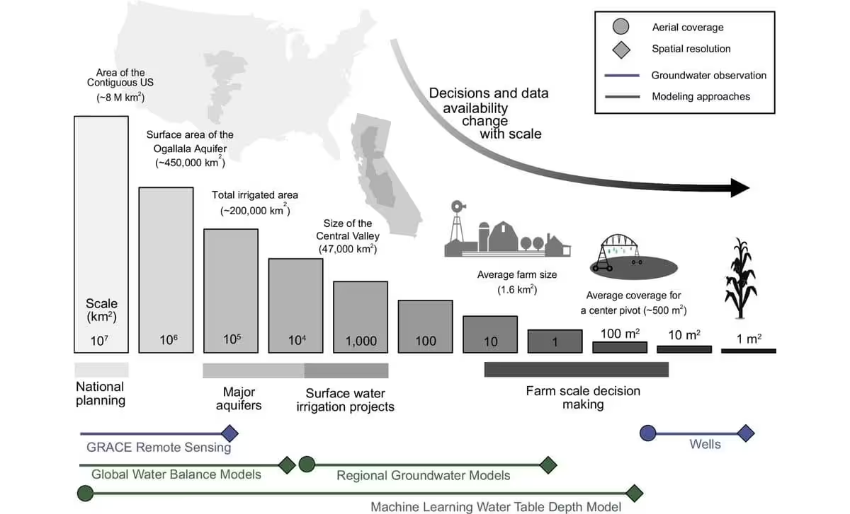
The jump in resolution is critical for accuracy. Earlier models often operated at a scale of one kilometer, and satellite-based programs like NASA’s GRACE mission function at a resolution of roughly 300 kilometers—nearly 10,000 times coarser than the new map. To demonstrate the impact of this granularity, the researchers tested a 100-kilometer resolution version of their data, which resulted in an 18% underestimation of total groundwater volume.
The study further reveals that 40% of the contiguous U.S. features a water table less than 10 meters deep. Condon emphasizes that this specific depth is the zone where vital groundwater, plant, and land-surface interactions occur, highlighting the deep connectivity of these ecosystems.
Capturing the Human Footprint
To build the model, the team synthesized historical data dating back to 1895 alongside variables including temperature, precipitation, stream proximity, and soil composition. A notable advantage of this approach is its ability to identify the influence of human activity. Because the training data included decades of historical records, the machine learning model successfully “learned” the signatures of groundwater pumping and depletion.
Maxwell explained that the model inherently accounts for human-driven stress, which is often invisible in traditional static maps. By providing this new mapping tool to regional water managers and agricultural producers, researchers hope to foster more sustainable land and water use strategies.
Ultimately, the project serves as a reminder of the ubiquity of our subsurface water. As Condon concluded, while the depth may vary, groundwater is a constant presence beneath our feet, waiting to be managed with better, data-driven insights.
This article has been fact checked for accuracy, with information verified against reputable sources. Learn more about us and our editorial process.
Last reviewed on .
Article history
- Latest version
Reference(s)
- “Reed Maxwell - Princeton Engineering.”, August 24, 2021 Princeton Engineering <https://engineering.princeton.edu/faculty/reed-maxwell>.
- “Grant Ferguson - School of Environment and Sustainability.” sens <https://sens.usask.ca/people/faculty/core-faculty/grant-ferguson.php>.
- “Laura Condon.” Hydrology and Atmospheric Sciences <https://has.arizona.edu/person/laura-condon>.
- “GRACE | Missions – GRACE Tellus.” GRACE Tellus <https://grace.jpl.nasa.gov/mission/grace/>.
- Gardner, Emily. “Report: 13 Great Lakes’ Worth of Water Underlies the Contiguous United States.”, January 26, 2026 American Geophysical Union <https://eos.org/articles/report-13-great-lakes-worth-of-water-underlies-the-contiguous-united-states>.
- <https://www.sciencedirect.com/topics/agricultural-and-biological-sciences/water-table>.
Cite this page:
- Posted by Karan Das