NASA Astronaut Photo Reveals 2.5-Billion-Year-Old Metal-Rich Stripe Across Zimbabwe
NASA satellite imagery uncovers a dark ancient scar in Zimbabwe, exposing a 2.5‑billion‑year geological history hidden beneath the ground.
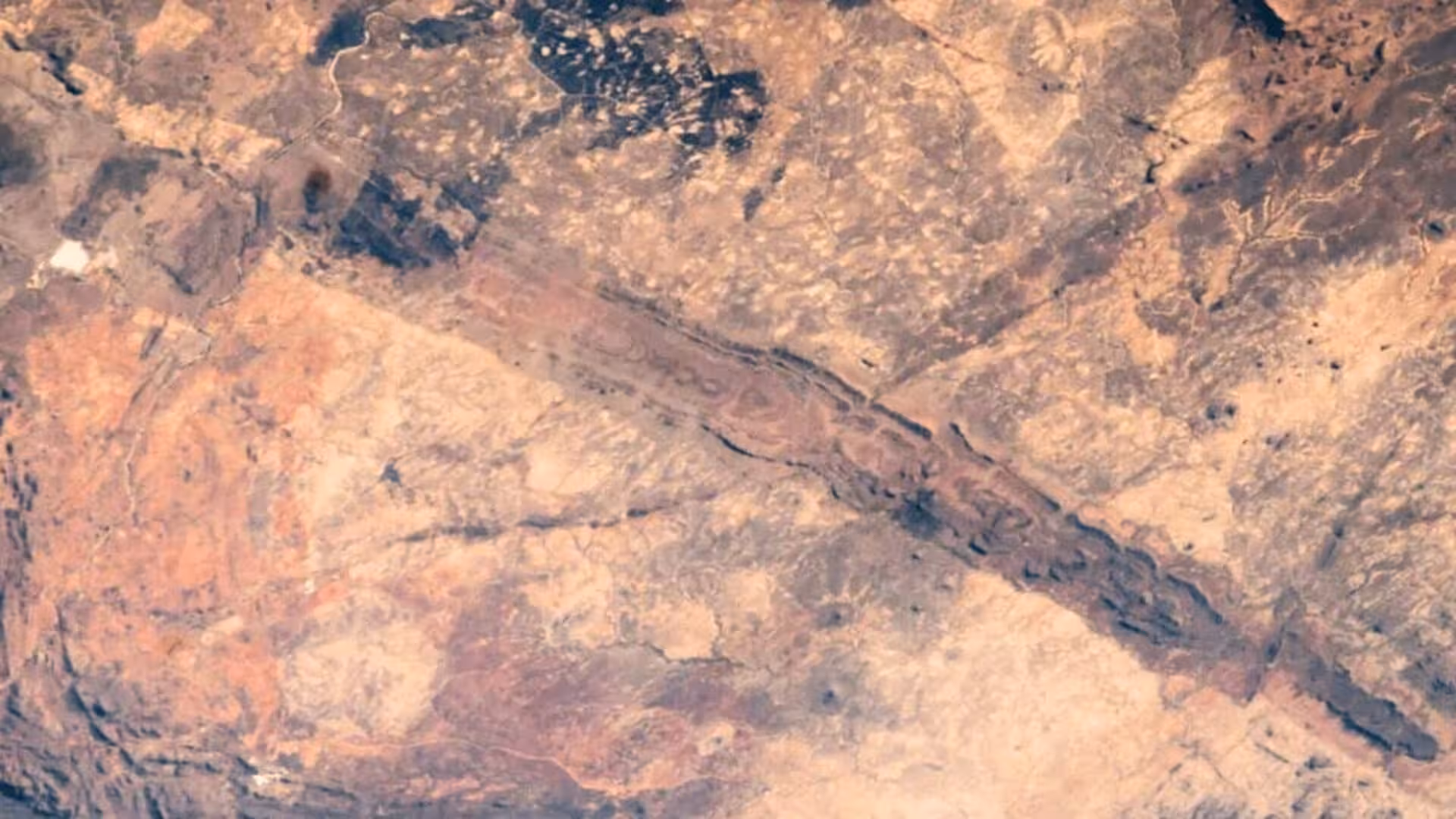
From the International Space Station, a stark, straight-dark line slices through central Zimbabwe. The feature is the Great Dyke of Zimbabwe, an igneous body formed roughly 2.5 billion years ago that hosts some of the region’s richest metal deposits.
Astronauts captured the view on 30 September 2010, and the image was later highlighted by the NASA Earth Observatory as a striking illustration of one of southern Africa’s most iconic geological structures.
A 550‑km Belt of Primordial Rock
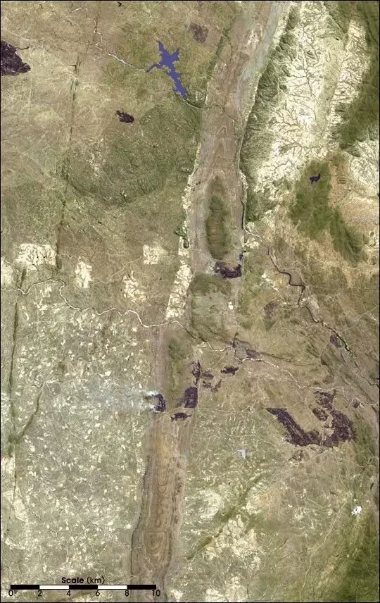
Stretching over 550 kilometers (about 342 miles) from northeast to southwest, the Great Dyke is surprisingly narrow—its width varies between 3 and 12 kilometers—yet it stands out clearly in satellite imagery.
The formation originated deep underground when molten magma forced its way into older crustal rocks and solidified in place. NASA classifies it as a layered mafic intrusion, a dark, iron‑ and magnesium‑rich rock that solidified in successive layers before later erosion exposed portions of the body.
The Dyke pierces the ancient rocks of the African craton, the stable core underlying much of the continent. Its cross‑section resembles a keel, indicating that magma rose through deep fractures while the crust experienced extensional forces.
What the ISS Photo Reveals
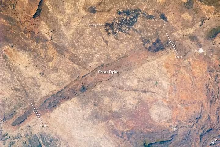
The frame concentrates on the Dyke’s southern segment, where the dark band contrasts sharply with surrounding terrain, making the structure easy to trace from space.
Expedition 25 crew members used a Nikon D2Xs equipped with a 180 mm lens to record the scene. NASA later cropped and enhanced the image to boost contrast, stripping away lens artifacts to showcase surface details more clearly.
The same snapshot captures evidence from vastly different epochs. Near the top‑center, two large burn scars mark recent fire events, while younger fault lines dissect and shift sections of the Dyke, illustrating a layered record of geological activity.
Why This Intrusion Holds Valuable Metals
Layered mafic intrusions attract attention because the cooling process can segregate minerals into distinct layers, concentrating economically important metals in specific zones.
Among the suite of elements associated with the Great Dyke are chromium, nickel, copper, platinum, titanium, iron, vanadium and tin. Chromium occurs chiefly as chromite, while platinum is also abundant, making these two metals the most commercially significant resources of the formation.
The concentration of these minerals has turned the Dyke into more than a geological curiosity; it underpins a mining corridor that targets chromite and platinum deposits wherever they are most richly concentrated.
How Tectonics and Erosion Modified the Dyke
Post‑formation tectonic activity has fractured and offset portions of the intrusion. In the NASA image, arrows highlight younger faults that have displaced segments of the Dyke, evidencing the long‑term deformation of the structure.
These disruptions explain why the Dyke does not appear as a seamless, untouched line. Instead, it is a relic of ancient magmatism that has been exposed, broken, and reshaped by millions of years of erosion and crustal movement.
Viewed from orbit, the Great Dyke transforms deep geological time into a visible imprint: a 2.5‑billion‑year‑old igneous belt stretching over 550 kilometers across Zimbabwe, bearing rich chromium‑bearing chromite and platinum deposits amid a landscape marked by fire, faulting and ongoing erosion.
This article has been fact checked for accuracy, with information verified against reputable sources. Learn more about us and our editorial process.
Last reviewed on .
Article history
- Latest version
Reference(s)
- Migrate, NASA. “Great Dyke of Zimbabwe - NASA Science.”, October 11, 2010 NASA <https://science.nasa.gov/earth/earth-observatory/great-dyke-of-zimbabwe-46341/>.
Cite this page:
- Posted by Karan Das