New Digital Map Reveals Why Not All Roads Actually Led To Rome
A vast new map of 186,000 miles of Roman roads is debunking centuries-old myths about how the empire’s complex overland transport network actually functioned.
The enduring adage that “all roads lead to Rome” has long served as a shorthand for the reach and authority of the Roman Empire. However, a massive new quantitative analysis of nearly 300,000 kilometers of ancient thoroughfares is forcing a rewrite of this historical narrative. By mapping the connectivity of the Roman world, researchers have discovered that the imperial capital was far from the center of gravity for the empire’s overland transit network.
The study, published in Nature Communications, utilized a sophisticated digital model known as Itiner-e to reconstruct the Roman infrastructure across Europe, North Africa, and the Middle East. By analyzing more than 10,000 intersections and 14,000 road segments, the team evaluated the system based on terrain, travel efficiency, and strategic importance, challenging decades of traditional historical assumptions.
Shifting the Center: Rome as a Peripheral Hub
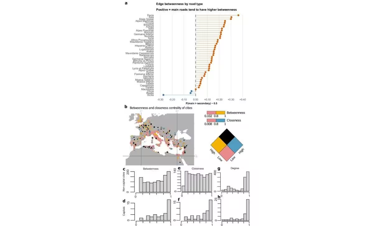
Contrary to the belief that Rome sat at the heart of all activity, the data reveals that the capital functioned more as an “appendix” to the broader network. Because of its location midway down the Italian Peninsula, Rome was effectively sidelined from the primary continental corridors that facilitated movement between the empire’s most critical provinces.
Instead, the study highlights the vital role of other major hubs. Byzantium—the precursor to Constantinople—emerged as a pivotal gateway, bridging European and Asian territories via the Bosporus. Other key cities, including Antioch, Ancyra (modern-day Ankara), and Corinth, acted as the true engines of regional and imperial logistics. A significant overland corridor spanned the North African and Levantine coasts, funneling movement through Anatolia into Europe and onward to the Po Valley, largely bypassing the Roman capital altogether.
Co-author Tom Brughmans of Aarhus University suggests that while Rome was not the geometric heart of the roads, its influence was bolstered by its proximity to Mediterranean maritime routes. The researchers acknowledge that future studies integrating sea and river travel alongside road networks will be essential to capturing a truly comprehensive picture of Roman mobility.
Engineering Reality: The Myth of Absolute Straightness
The research also deconstructs the popular image of Roman roads as perfectly straight lines stretching across the horizon. While Roman engineers certainly preferred direct paths when the topography allowed, the actual network was significantly more nuanced.
By measuring the sinuosity of the roads—a ratio comparing actual distance to straight-line distance—the study found that the ancient system was actually less direct than modern major highways. Roman roads achieved maximum efficiency in flat regions like North Africa, the Pannonian basin, and parts of northwestern Europe. However, in mountainous terrain, engineers were forced to adapt, utilizing valleys and mountain passes that necessitated winding paths.
The technical sophistication of these builders remains evident: over 90 percent of the mapped network—nearly 271,000 kilometers—was constructed with a slope of less than 16 percent, keeping routes viable for wheeled transport. When terrain posed an obstacle, the Romans utilized impressive civil engineering techniques, including terraces, retaining walls, and occasionally, tunnels.
A Legacy of Infrastructure
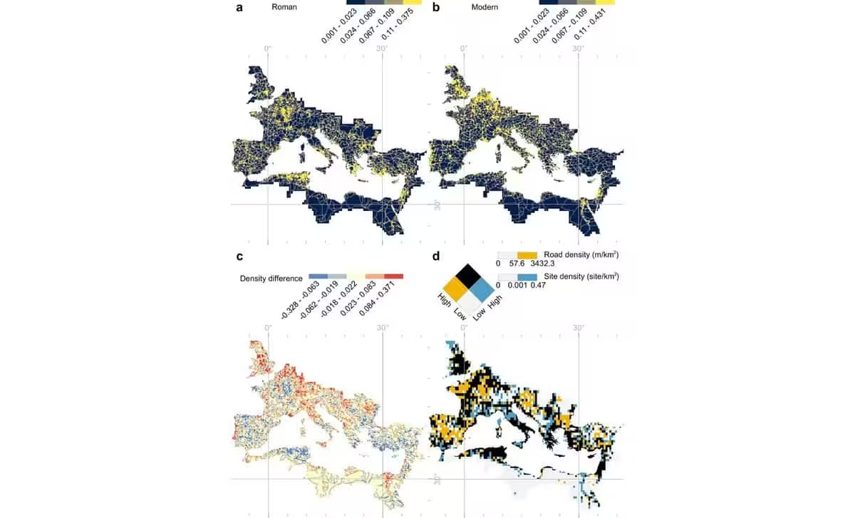
The correlation between ancient Roman roads and modern road networks is far from uniform. While some regions, particularly in northern Italy and parts of Britain, have seen a massive expansion of modern infrastructure, other areas—notably parts of Greece and North Africa—feature fewer major modern roads today than they did under Roman administration. This divergence underscores how transportation needs have evolved, reflecting shifting economic priorities and urban development over the last two millennia.
Ultimately, the study paints a picture of a dynamic, decentralized system. The Roman transportation network was not a static, Rome-centric monolith, but a responsive, geographically grounded infrastructure that adapted to the complexities of provincial life and the diverse landscapes of an expanding empire.
This article has been fact checked for accuracy, with information verified against reputable sources. Learn more about us and our editorial process.
Last reviewed on .
Article history
- Latest version
Reference(s)
- Pažout, Adam. “Network science reveals the structure and lasting impact of the Roman road system - Nature Communications.”, vol. 17, no. 1, September 15, 2026, pp. 9551 Nature, doi: 10.1038/s41467-026-75453-3. <https://www.nature.com/articles/s41467-026-75453-3>.
- <https://www.au.dk/en/[email protected]/>.
Cite this page:
- Posted by Zara Tariq