NASA’s Curiosity Rover Reaches a New Spot on Mars and Makes a Remarkable Discovery
Curiosity reaches a stable Mars site for in-depth study of ancient geology and bedrock
After a flawless trek across rugged terrain, NASA’s Curiosity rover now occupies a spot that mission engineers describe as exceptionally secure and level. The latest mission briefing notes that this advantageous setting lets scientists conduct close‑up examinations of ancient rocks and nearby formations that could unlock clues about Mars’ early environment.
Precision Parking Enables In‑Depth Study of Martian Rocks
Finding a flat, rock‑free area on a planet riddled with slopes, loose regolith and unpredictable obstacles is a rare boon for a rover. Stability influences which instruments can be deployed and how much data can be harvested from a given site. Curiosity’s current location offers the type of terrain that the team hopes for but seldom secures.
“Not only did our drive execute perfectly, Curiosity ended up in one of the safest, most stable parking spots of the whole mission,” wrote Lucy Thompson, APXS Collaborator and Senior Research Scientist at the University of New Brunswick.
Credit: NASA/JPL-Caltech/LANL
The relevance of a stable platform becomes evident when the rover prepares its science campaign. Teams often must account for the possibility that one or more wheels could be perched on uneven ground, which would restrict the robotic arm’s reach and limit the placement of analytical instruments. In this instance the ground held firm, allowing the crew to carry out the full suite of planned measurements. The secure stance also let Curiosity extend its arm and begin a fresh round of surface examinations that may shed light on the surrounding geology.
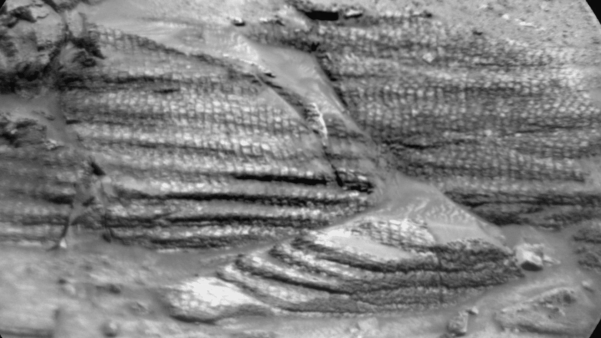
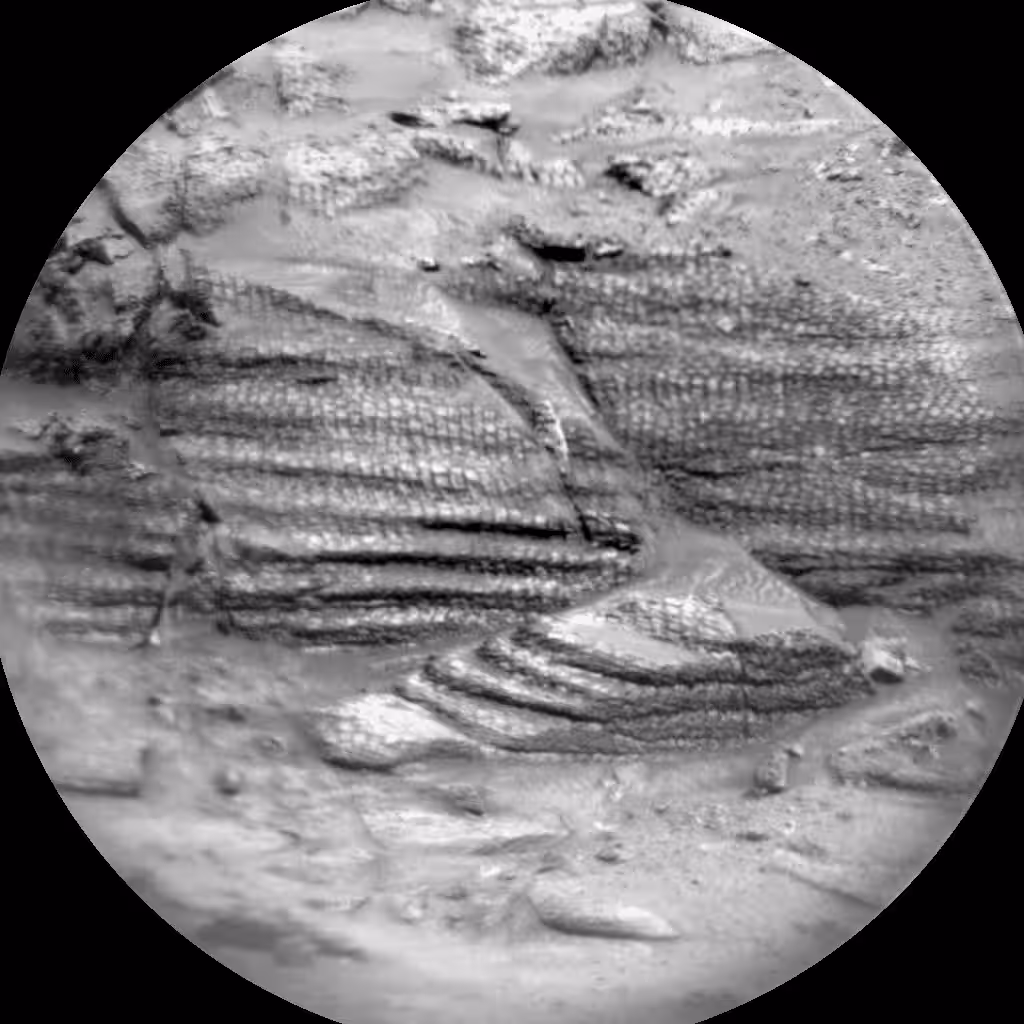
Probing the Tarija Bedrock and Unusual Boxwork Formations
The rover is currently targeting a rock outcrop named Tarija, employing its most capable instruments such as the Alpha Particle X‑ray Spectrometer (APXS) and ChemCam to decode the rock’s chemistry. Complementary imaging is being gathered by Mastcam and MAHLI, which capture high‑resolution views of the sample and its context.
A key objective is to map the composition of potential boxwork structures—intricate, honey‑comb‑like features that could preserve traces of ancient groundwater flow. By characterizing these patterns, scientists hope to reconstruct the behavior of fluids that once percolated through the Martian crust billions of years ago.
Tarija’s data will be integrated into a larger effort to link localized chemistry with regional geological trends. Each measurement enriches the evolving narrative of how Mars transitioned from a wetter, potentially habitable world to the cold, arid planet observed today. Joint analysis of mineralogy and texture aims to produce a comprehensive model of the processes that sculpted the landscape over geological time.
Surveying Adjacent Landforms to Contextualize Findings
Beyond the primary rock, the mission plan includes extensive imaging of nearby features that could provide valuable context. NASA notes that Curiosity is focusing on a series of linear ridges to the north of its position and a possible fracture‑fill structure identified as Laguna del Bayo.
The rover is also revisiting the Mishe Mokwa outcrop, acquiring additional photographs to help determine how distinct rock layers interact and how tectonic forces have reshaped the area.
Combining close‑up compositional data with broad‑area visual surveys is a cornerstone of planetary exploration. While instrument readings reveal the makeup of individual targets, wide‑field imaging places those results within a broader environmental framework, allowing scientists to decide whether a particular rock is an isolated curiosity or part of a larger geological pattern that spans the region. This dual‑approach strategy has guided Curiosity’s investigations since it touched down in Gale Crater in 2012.
Upcoming 54‑meter Traverse Sets Stage for Autonomous Measurements
The confidence afforded by the stable ground has enabled engineers to schedule another modest drive, moving the rover roughly 54 meters (177 feet) toward its next scientific waypoint.
After the traverse, Curiosity will immediately commence a set of autonomous observations. The Mars Descent Imager (MARDI) will photograph the surface directly beneath the wheels, while ChemCam will autonomously select a suitable rock and conduct a chemical analysis without awaiting human input.
This article has been fact checked for accuracy, with information verified against reputable sources. Learn more about us and our editorial process.
Last reviewed on .
Article history
- Latest version
Reference(s)
- Carney, Stephen. “Curiosity Blog, Sols 4575-4576: Perfect Parking Spot - NASA Science.”, June 20, 2025 NASA <https://science.nasa.gov/blog/curiosity-blog-sols-4575-4576-perfect-parking-spot/>.
Cite this page:
- Posted by Bilal Abbasi