Hidden Freshwater Reservoir Discovered Beneath Great Salt Lake’s Salty Surface
Scientists discover a hidden freshwater ecosystem beneath a salty U.S. landscape, uncovered by towering reed mounds.
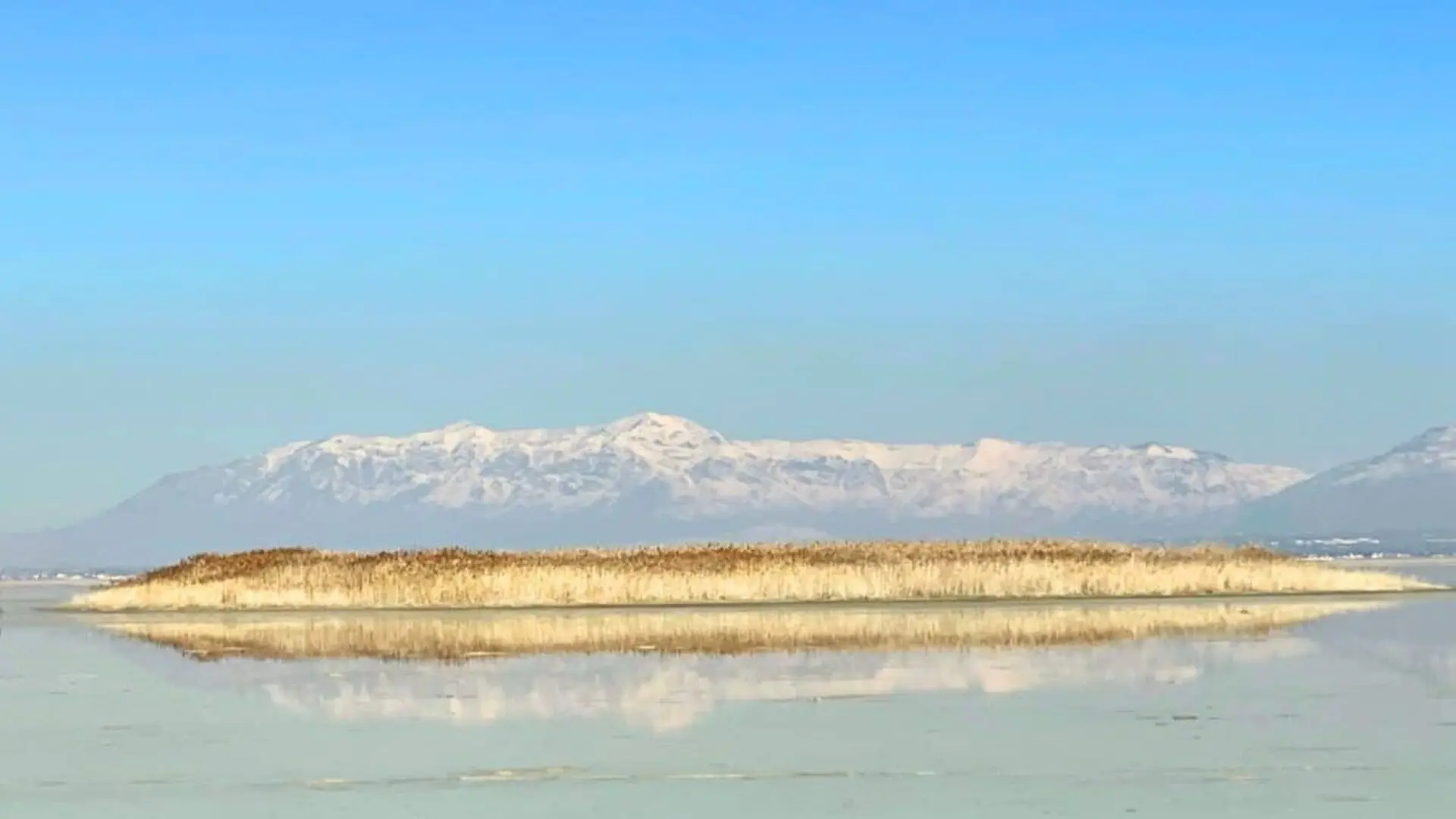
Researchers first noticed circular islands of tall reeds sprouting on the desiccated floor of Farmington Bay several years ago. Each mound, spanning 50 to 100 meters and capped with phragmites reeds up to 15 feet high, marks locations where pressurized freshwater forces its way upward through breaches in the lake’s low‑permeability layer. This visual cue prompted geophysicists at the University of Utah to investigate the hidden source, uncovering a much larger subsurface system than anticipated.
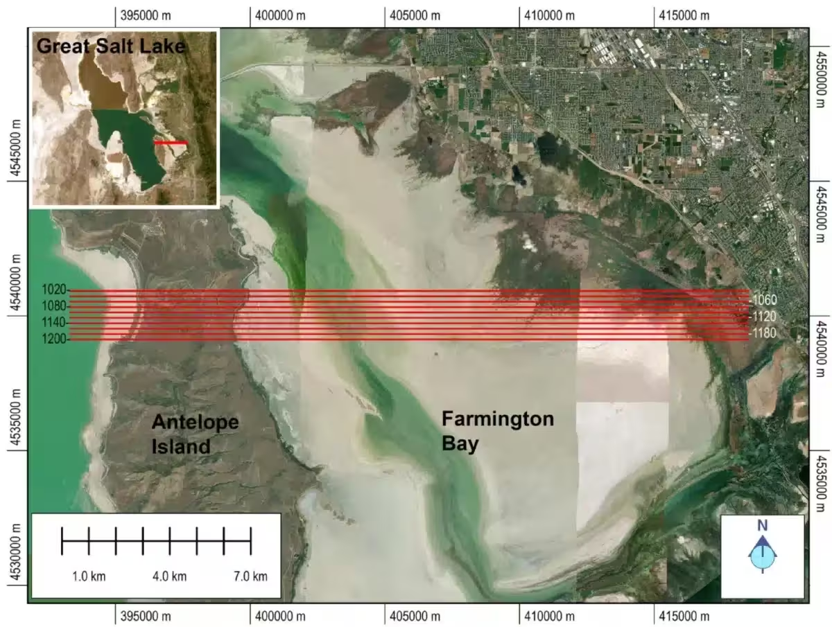
In a paper appearing in Scientific Reports, investigators describe a deep, freshwater‑filled aquifer beneath the Great Salt Lake’s hypersaline veneer. Airborne electromagnetic (AEM) measurements taken in February 2025 mapped the transition between brine and fresh water beneath Farmington Bay and the northern sector of Antelope Island, revealing freshwater‑saturated sediments that reach depths of 3 to 4 kilometers (approximately 10,000 to 13,000 feet).
Helicopter‑borne Electromagnetic Mapping Reveals Hidden Aquifer
To acquire the data, the Utah team hired a Canadian geophysical outfit to tow electromagnetic sensors beneath a helicopter. The aircraft completed ten east‑west flight lines across Farmington Bay and the north side of Antelope Island, covering a total of 154 miles. The system recorded electrical resistivity to roughly 100 meters depth, a method that distinguishes fresh water from brine because saline water conducts electricity far more efficiently.
Lead author Michael Zhdanov, a distinguished professor of geology and geophysics and director of the Consortium for Electromagnetic Modeling and Inversion (CEMI) at the University of Utah, highlighted that this represents the inaugural application of AEM techniques to detect freshwater beneath the thin, conductive salt layer capping the Great Salt Lake.
The resulting resistivity maps display a stark boundary: a conductive saline veneer near the surface gives way after only about 10 meters to a highly resistive zone interpreted as fresh water, extending across the entire surveyed region. One of the reed‑covered mounds sits directly above a point where this fresh water pierces the impermeable layer and rises toward the surface.
Freshwater Penetrates Deep Into the Lake Basin
The pattern surprised the investigators. Conventional hydrologic models predict that the denser brine would occupy the full subsurface beneath a terminal lake such as the Great Salt Lake, with fresh inflow confined to the margins. However, the AEM data suggest that fresh water spreads well into the lake interior, forming a deep volume that appears to move inward beneath the saline lens. Hydrologist Bill Johnson, a co‑author and professor of geology and geophysics, explained the finding on KPCW’s Cool Science Radio, noting that the pilot survey only covered a portion of the southeastern shoreline, leaving the full extent of the aquifer uncertain.
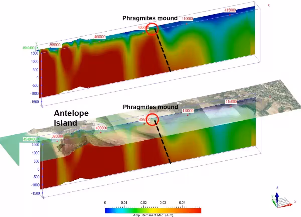
In addition to the AEM survey, Zhdanov’s team merged the electromagnetic data with magnetic measurements to produce three‑dimensional tomographic images of the subsurface. Magnetic inversion revealed that the basement beneath Farmington Bay’s playa lies shallower than 200 meters before dropping abruptly to depths of 3–4 kilometers. This structural break aligns with one of the reed mounds, marking a geological transition that warrants further investigation.
Implications for Dust Mitigation on the Exposed Playa
The discovery has immediate relevance to a growing public‑health concern. Declining lake levels have exposed roughly 800 square miles of playa, generating dust storms that transport toxic metals into surrounding Utah communities. Large‑scale reflooding of the playa faces logistical and economic hurdles.
Johnson and his collaborators are now assessing whether artesian groundwater emerging from the lake floor could be strategically applied to dampen dust‑prone zones without disrupting the deeper aquifer. He described the approach as a feasible short‑term measure for targeting specific emission hotspots, especially where broad reflooding remains unlikely.
The project forms part of a larger research initiative led by the University of Utah’s Department of Geology and Geophysics, with financial support from the Utah Department of Natural Resources and the Great Salt Lake Commissioners’ Office. Two additional studies have already emerged from this effort, according to the University of Utah’s research office, and more are expected as the work progresses.
If the AEM methodology can be expanded to cover the lake’s full 1,500‑square‑mile footprint, water‑resource managers would gain a far more detailed picture of the hidden freshwater reservoir beneath one of the Western Hemisphere’s largest terminal lakes.
This article has been fact checked for accuracy, with information verified against reputable sources. Learn more about us and our editorial process.
Last reviewed on .
Article history
- Latest version
Reference(s)
- Zhdanov, M. S.., et al. “Airborne geophysical imaging of freshwater reservoir beneath the eastern margin of Great Salt Lake.” Scientific Reports, vol. 16, no. 1, February 27, 2026 Springer Science and Business Media LLC, doi: 10.1038/s41598-026-40995-5. <https://doi.org/10.1038/s41598-026-40995-5>.
- Peek, Lynn. “Cool Science Radio | February 19, 2026.”, February 19, 2026 KPCW <https://www.kpcw.org/show/cool-science-radio/2026-02-19/cool-science-radio-february-19-2026>.
- “Freshwater under Great Salt Lake playa - @theU.” <https://attheu.utah.edu/research/freshwater-under-great-salt-lake-playa/>.
Cite this page:
- Posted by Vikram Desai