5,200 Hillside Holes Reveal Ancient Peruvian Marketplace And Counting System
Discover how 5,200 mysterious holes in Peru may expose an ancient network of trade, accounting and authority, hidden in plain sight.
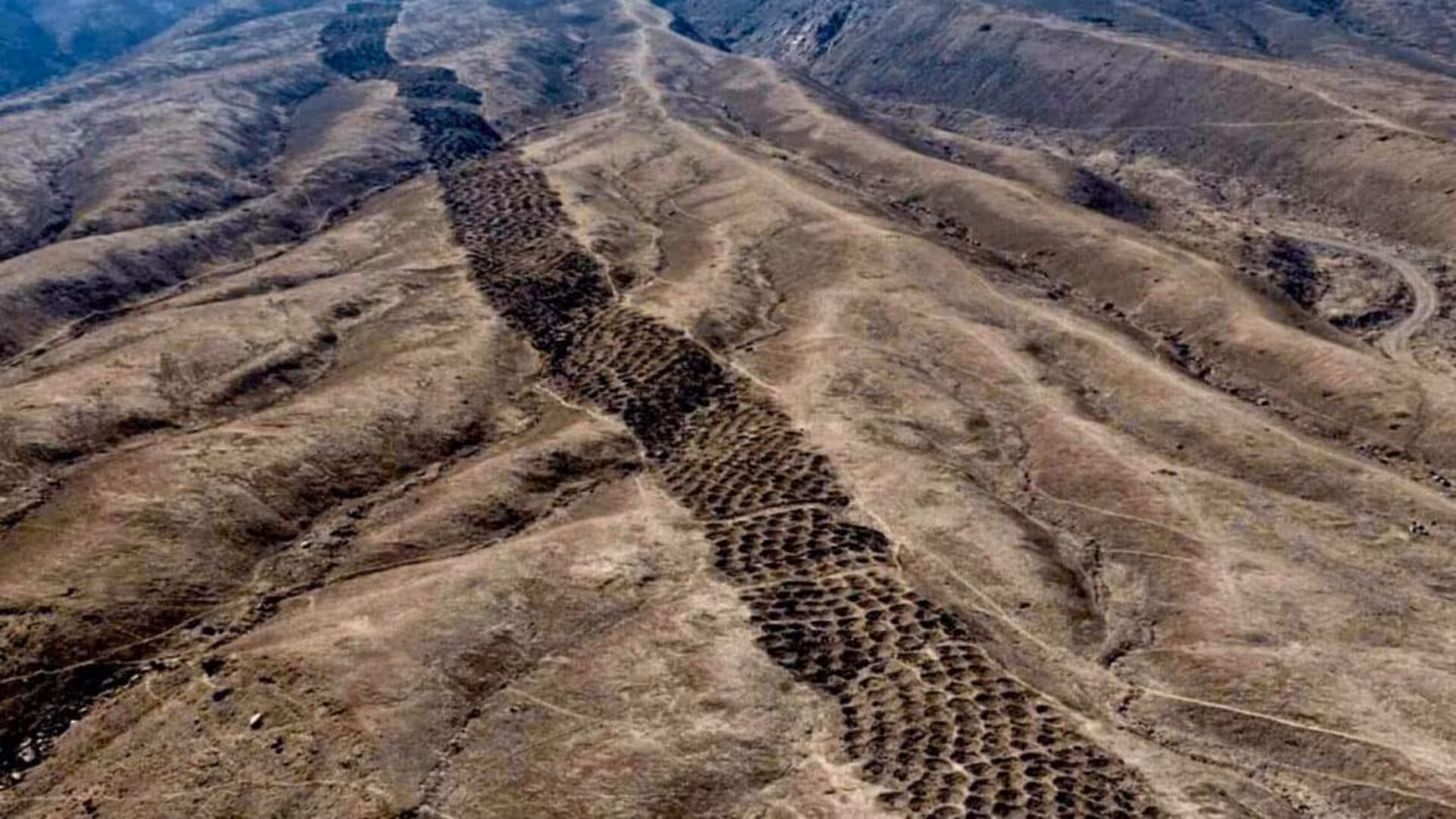
Monte Sierpe crowns a barren ridge in Peru’s Pisco Valley, its surface marked by a field of roughly 5,200 depressions arranged in repetitive rows and clusters. Known locally as the Band of Holes, the formation has confounded researchers since aerial images first highlighted it in 1933.
A recent Antiquity paper proposes that the pits were not accidental but part of an Indigenous accounting and exchange network that began under the Chincha Kingdom and continued during Inca hegemony, a hypothesis supported by drone mapping and sediment analyses.
Rather than interpreting the depressions as random cavities, gardens, or defensive features, the authors link their geometry, placement, and botanical residues to a system where commodities could be dropped, tallied, compared, and redistributed.
A Strategic Spot Along an Ancient Trade Axis
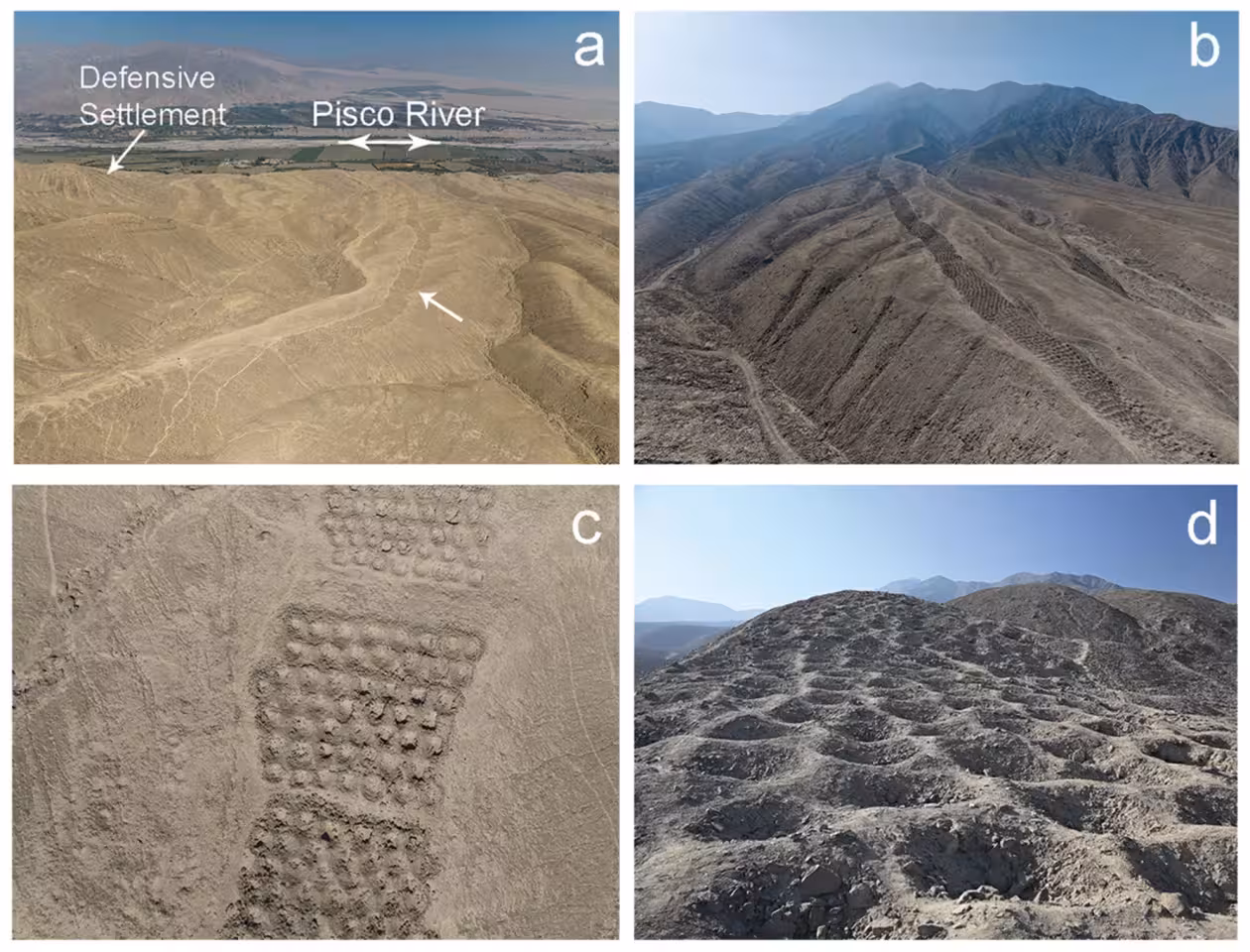
Monte Sierpe occupies the northern fringe of the Pisco Valley in southern Peru, about 35 km inland from the Pacific shoreline. It lies near the convergence of pre‑Hispanic routes and between two Inca administrative hubs, Tambo Colorado and Lima La Vieja.
Its setting is also a transitional zone where coastal plains meet highland valleys, a landscape that historically linked diverse communities—farmers, fishers, caravan traders, and officials—each bringing distinct resources to the exchange.
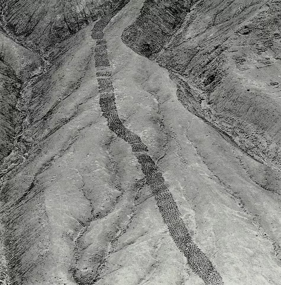
According to a University of Sydney report, the complex stretches over 1.5 km, with individual pits ranging from 1 to 2 m in diameter and 0.5 to 1 m deep. Rather than forming a continuous trench, the depressions are grouped into segments separated by open intervals.
Those intervals likely facilitated pedestrian traffic, implying a design intended not only for aerial visibility but also for on‑site circulation and interaction.
Drone Survey Uncovers Repeating Spatial Logic
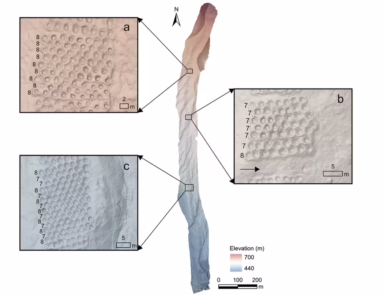
High‑resolution aerial imagery captured by the research team reveals that the holes are organized into dense blocks, each exhibiting consistent counts and discernible numeric patterns.
The authors liken this arrangement to a khipu, the knotted‑cord record‑keeping device used by the Inca to monitor commodities, labor, and tribute. While the material differs, the systematic grouping at Monte Sierpe could have functioned as a visual counting aid.
The study notes a resemblance between the hillside layout and at least one khipu recovered from the same valley, suggesting that the site may have acted as a landscape‑scale ledger, with each cluster representing a unit of goods or obligation.
Radiocarbon dating of charcoal from a single pit yields a calibrated range of AD 1320–1405, while associated pottery points to construction in the Late Intermediate Period—coinciding with Chincha dominance and later Inca administration.
Botanical Residues Reveal What Was Placed Inside
Sediment samples extracted from the depressions contain pollen and micro‑botanical traces of cultivated and wild species, including maize, cotton relatives, chili peppers, sweet‑potato kin, and reed plants used for basketry.
These botanical signatures are noteworthy because the arid ridge where Monte Sierpe sits is unsuitable for many of those crops. Several pollen types are heavy or insect‑borne, indicating that they were unlikely to have arrived via wind alone.
The authors infer that people likely transported these items in woven containers, bundles, or mats, using reeds and bulrushes both as lining material for the pits and as transport media.
Rather than serving as a conventional warehouse, the pits may have functioned as visible counters, allowing participants to assess quantities at a glance during public exchanges.
From Barter Hub to Inca Tribute Ledger
The researchers argue that Monte Sierpe originated as a barter marketplace under the Chincha Kingdom, where goods were swapped directly without monetary mediation but still required a shared metric for equivalence.
Historical records describe the Chincha region as a dense network of farms, fishing villages, and merchant caravans—llama‑drawn packs moving inland and rafts navigating the coast—supplying a variety of products to a regional economy.
In that context, the array of holes could have provided a communal framework for depositing, comparing, and negotiating staples such as maize, cotton, and other commodities.
After the Inca incorporated the area, the same architectural feature may have been repurposed for tribute accounting, aligning with the empire’s extensive bureaucratic system for tracking labor and goods.
The authors stress that the site represents a localized Indigenous accounting system rather than a fully resolved mystery. Ongoing work—targeted excavations, additional radiocarbon dates, expanded sediment testing, and comparative analysis of nearby khipus—should clarify the precise functions of the Band of Holes.
This article has been fact checked for accuracy, with information verified against reputable sources. Learn more about us and our editorial process.
Last reviewed on .
Article history
- Latest version
Reference(s)
- Bongers, Jacob. “Indigenous accounting and exchange at Monte Sierpe (‘Band of Holes’) in the Pisco Valley, Peru | Antiquity | Cambridge Core.”, vol. 100, no. 409, pp. 145-163. Cambridge Core, doi: 10.15184/aqy.2025.10237. <https://www.cambridge.org/core/journals/antiquity/article/indigenous-accounting-and-exchange-at-monte-sierpe-band-of-holes-in-the-pisco-valley-peru/41D83389D230D99CFF18194CF274A9A3>.
- “Mysterious holes in the Andes may have been an ancient marketplace, study suggests.” The University of Sydney <https://www.sydney.edu.au/news-opinion/news/2025/11/10/mysterious-holes-in-the-andes-may-have-been-an-ancient-marketplace-new-research-suggests.html>.
Cite this page:
- Posted by Vikram Desai