Cascadia Earthquake Risk Found To Be Higher Than Expected Due To Shallower Plate Depth
Scientists have discovered a hidden geological feature beneath Oregon that may finally explain the complex earthquake behavior of the Cascadia subduction zone.
A fresh analysis of the Cascadia subduction zone has revealed that the Juan de Fuca plate is situated significantly closer to the surface beneath northern Oregon than earlier geological models had suggested. This discovery, detailed in the journal Science Advances, offers a critical update to our understanding of the seismic architecture along the Pacific Northwest coast, where the oceanic plate is slowly sliding beneath the North American continent.
The Cascadia subduction zone is a massive, high-risk fault system capable of generating magnitude 9 megathrust earthquakes. Because northern Oregon exhibits less frequent seismic activity than other sections of the margin, it has historically been difficult for geologists to map the exact depth and configuration of the fault interface. By integrating recent terrestrial seismic readings with broader offshore observations, researchers have effectively bridged this knowledge gap.
Increased Potential for Surface Shaking
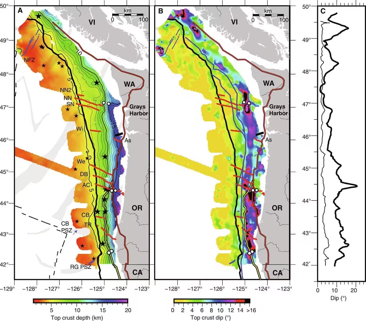
According to findings presented at the 2026 Annual Meeting of the Seismological Society of America, the interface between the Juan de Fuca plate and the North American plate sits at a depth of approximately 20 kilometers near the coastline. This measurement is roughly 5 kilometers shallower than previous benchmarks.
U.S. Geological Survey seismologist Erin Wirth, who led the research, explained that the depth of a rupture is a major factor in determining the intensity of ground motion. Because the fault is shallower than expected, seismic energy has a shorter distance to travel, resulting in less attenuation. This could elevate estimates of peak ground acceleration during a future megathrust event by 9 to 17 percent.
Sedimentary Basins and Wave Amplification
In addition to mapping the plate interface, the research team identified a deep sedimentary basin located beneath Tillamook, Oregon. To gather this data, the scientists deployed a dense network of 192 nodal seismometers across an area stretching from the coast to Portland during the summer months of 2021 and 2022.
The presence of sedimentary basins can complicate seismic risk, as softer, looser materials act like a bowl of jello, trapping and amplifying incoming seismic waves. Wirth compared the effect to previous observations in the Seattle Basin, noting that these geological features can cause ground shaking to persist for significantly longer durations. Understanding the specific thickness and geometry of these basins is essential for developing accurate, localized earthquake hazard maps.
Refining Future Risk Assessments
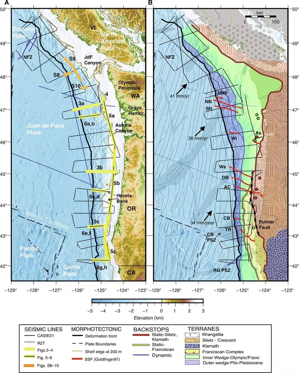
The effort to clarify the subduction zone’s structure relies heavily on merging land-based nodal data with offshore recordings. By aligning these findings with broad-scale data covering the coastline from Vancouver Island down to northern California, researchers have produced a significantly more refined model of the region’s subterranean architecture.
As the team continues to process the data, they are shifting their focus toward the Tualatin Basin near Portland. These ongoing investigations are intended to provide a comprehensive view of how regional geological features dictate the way shockwaves propagate through the crust, ultimately helping communities in the Pacific Northwest prepare more effectively for a major seismic event.
This article has been fact checked for accuracy, with information verified against reputable sources. Learn more about us and our editorial process.
Last reviewed on .
Article history
- Latest version
Reference(s)
- Carbotte, Suzanne M.., et al. “Subducting plate structure and megathrust morphology from deep seismic imaging linked to earthquake rupture segmentation at Cascadia.” Science Advances, vol. 10, no. 23, June 7, 2024 American Association for the Advancement of Science (AAAS), doi: 10.1126/sciadv.adl3198. <https://www.science.org/doi/10.1126/sciadv.adl3198>.
- <https://www.sciencedirect.com/topics/earth-and-planetary-sciences/juan-de-fuca-plate>.
- <https://www.sciencedirect.com/topics/earth-and-planetary-sciences/north-american-plate>.
- “Erin Wirth Moriarty.” <https://www.usgs.gov/staff-profiles/erin-wirth-moriarty>.
Cite this page:
- Posted by Vikram Desai