Satellite Images Reveal How Water Diversions Sank Bolivia’s Lake Poopó
A massive Bolivian lake once seen from space has almost disappeared, exposing the rapid forces that can unravel an entire landscape.
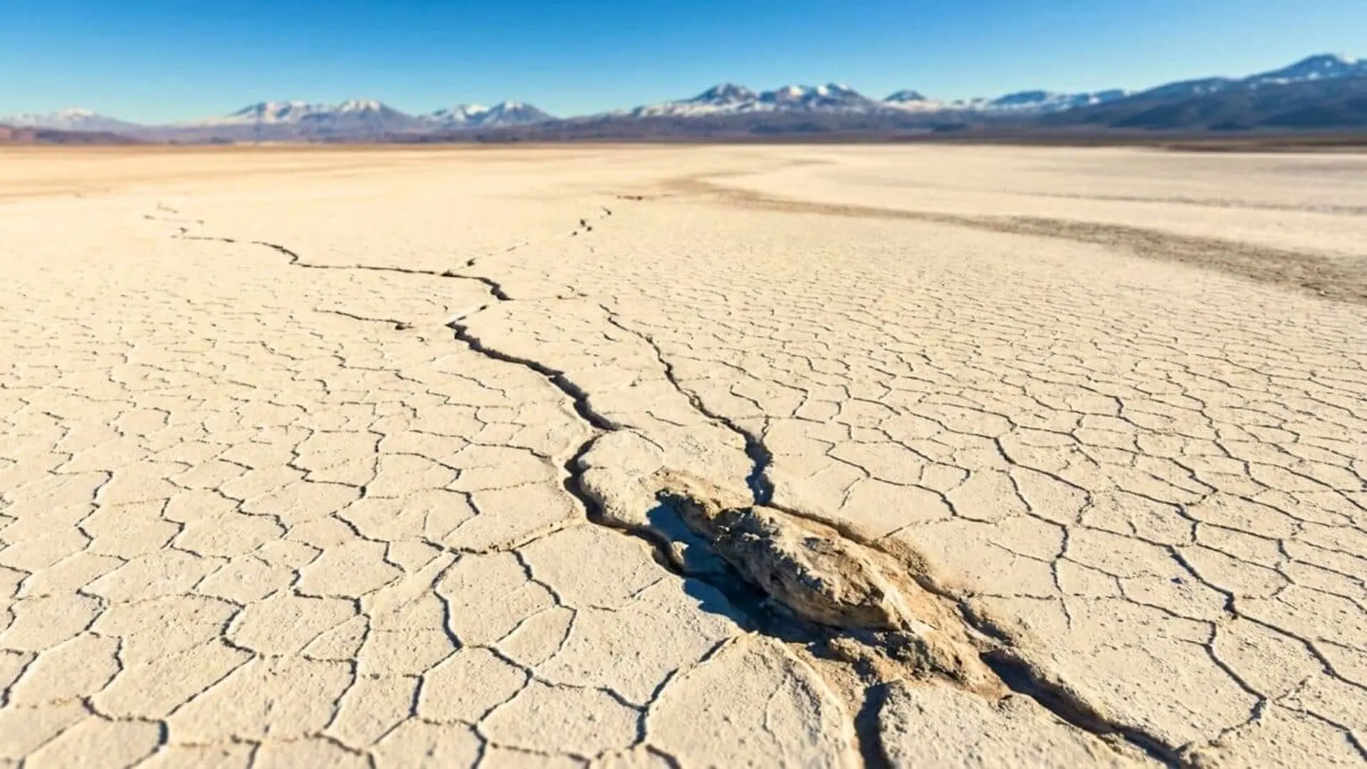
Lake Poopó, once Bolivia’s second‑largest lake, vanished by the end of 2015 after a prolonged decline in water levels. A combination of drought, an El Niño episode, and later investigations of water‑use practices pinpointed river diversions and inadequate management as the dominant drivers.
Situated on the Altiplano at roughly 3,700 m above sea level, the shallow saline basin expands to nearly 70 km during the rainy season and once covered close to 3,000 km². By 2021, the former lakebed had largely turned into a broad, salty mud flat.
Satellite Snapshots Capture the Shrinkage
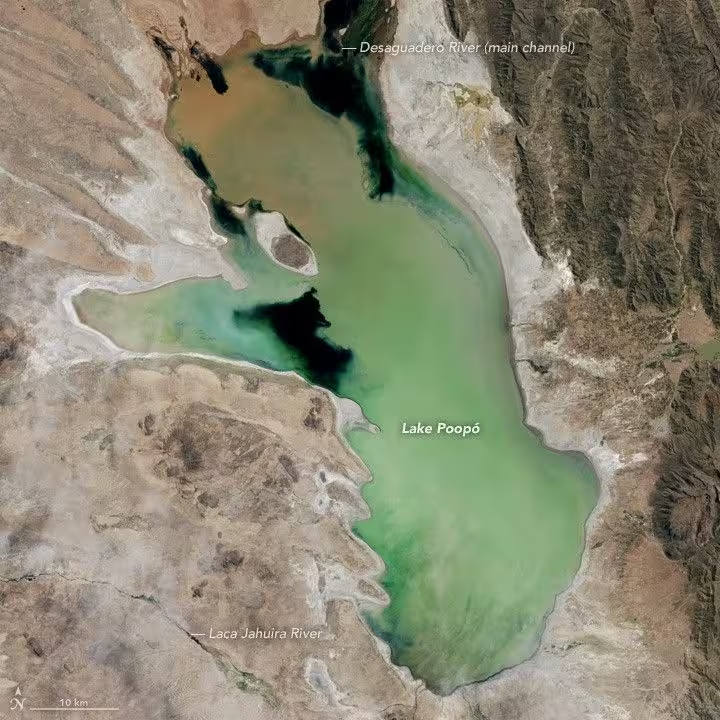
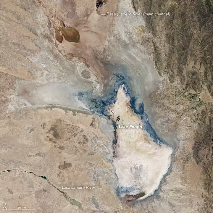
NASA Earth Observatory combined two Landsat 8 scenes to illustrate the transformation. The April 12 2013 image still shows a water‑filled basin, whereas the January 15 2016 frame depicts an almost completely dry expanse.
Because the lake typically reaches a depth of no more than three metres, even modest reductions in inflow can translate into extensive surface retreat.
The basin has experienced previous dry spells, notably in 1994, when water receded for several years before the ecosystem began to recover.
Seasonal rains from December through March normally replenish the lake directly and boost the flow of the Desaguadero River. During the 2015‑16 wet season, however, the region remained arid.
Diversions Slash Desaguadero Inflows
The Desaguadero River, which transports water southward from Lake Titicaca, serves as Poopó’s primary source. Over decades, increasing volumes were diverted for agricultural irrigation and mining operations, reducing the amount that reaches the lake.
By early 2016, inflow had dwindled to a mere trickle. Lake researcher Lisa Borre noted that water‑management authorities were insufficiently opening control gates, while sediment from mining activities further obstructed river channels.
Concurrent El Niño‑related dryness and heightened evaporation compounded the shortage. Regional temperatures have risen by about one °C over the past century, yet Borre emphasized that existing basin plans already flagged these vulnerabilities, suggesting that climate factors alone could not account for the collapse.
The surge in quinoa cultivation around Oruro, north of the lake, intensified water demand. A report compiled by PreventionWeb linked the expansion of quinoa farming—up 45.5 % between 1980 and 2011 and another 60 % in the following five years—to broader increases in agricultural, urban, and mining water use.
Satellite Analysis Highlights Management Failures
Researchers Juan Torres‑Batlló and Belén Martí‑Cardona examined two decades of remote‑sensing data from the Poopó catchment. Their assessment revealed that precipitation supplied more water than evaporation removed during the study period.
This imbalance led them to attribute the lake’s disappearance chiefly to inefficient water‑resource governance rather than to climate variability alone.
Nonetheless, other studies note that the rainy season has become shorter yet more intense, delivering less water at the end of the dry period while concentrating flows in the wet months.
Torres‑Batlló and Martí‑Cardona recommend tighter regulation of water withdrawals and the creation of storage capacity during wet periods to sustain releases in drier intervals, taking into account the competing needs of irrigation, mining, and other river users.
Communities and Ecosystems Suffer the Loss
Prior to its desiccation, Lake Poopó supported vibrant fishing villages and a diverse assemblage of roughly 200 species, including fish, birds, reptiles, and mammals. The rapid recession of water led to the disappearance of many of these organisms.
Indigenous groups such as the Urus‑Muratos, whose traditional livelihoods depended on lake‑based fishing, were forced to relocate toward urban centers.
Although occasional above‑average rains have temporarily restored some water after 2015, by 2021 the lake remained largely a salt‑encrusted plain, underscoring the long‑term nature of the crisis.
This article has been fact checked for accuracy, with information verified against reputable sources. Learn more about us and our editorial process.
Last reviewed on .
Article history
- Latest version
Reference(s)
- Migrate, NASA. “Bolivia’s Lake Poopó Disappears - NASA Science.”, January 23, 2016 NASA <https://science.nasa.gov/earth/earth-observatory/bolivias-lake-poopo-disappears-87363/>.
- <https://www.preventionweb.net/news/lake-poopo-why-bolivias-second-largest-lake-disappeared-and-how-bring-it-back>.
Cite this page:
- Posted by Karan Das