Ancient River Landscape Hidden Beneath Antarctica Revealed After 34 Million Years
Hidden deep beneath Antarctica’s ice, researchers have uncovered new evidence revealing the continent’s long-lost history from a vastly different era.
Researchers have uncovered a vast, prehistoric landscape hidden deep beneath the East Antarctic Ice Sheet, a terrain that has remained shielded from the elements for more than 34 million years. This ancient region, roughly the size of Wales, provides a rare look at the continent as it existed long before it was entombed in ice.
For decades, the East Antarctic Ice Sheet—a massive expanse covering more than 10 million square kilometers—has obscured the bedrock beneath it. While scientists have long theorized that a landscape existed below, this new discovery is significant because the terrain appears remarkably intact, preserved in a state that reflects its pre-glacial history.
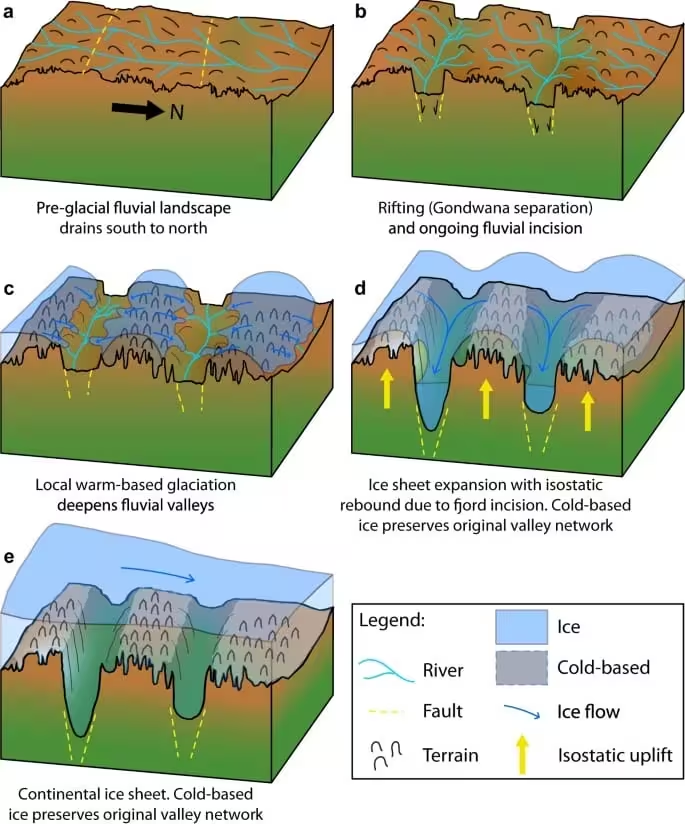
Long before the onset of the current polar climate, Antarctica was a vibrant component of the supercontinent Gondwana, sharing a landmass with modern-day Africa, South America, and Australia. The region was once defined by lush forests and flowing river systems. The transformation into a frozen wasteland began approximately 34 million years ago, and mapping this buried geography offers critical clues into how the planet transitioned into its current icy epoch.
Advanced Mapping Reveals a Frozen Time Capsule
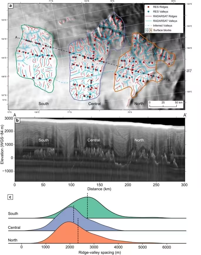
The research, led by Stewart Jamieson of Durham University, utilized satellite data from the RADARSAT constellation. By identifying minute, subtle irregularities on the surface of the ice, the team was able to map the topography hidden far below. These surface variations act as markers for the underlying valleys, ridges, and channels, allowing researchers to reconstruct the landscape as it appeared millions of years ago.
“It’s like uncovering a time capsule,” Jamieson said of the find. He added that the state of the landscape points to its age, noting that it “must be a very old landscape carved by rivers before the ice sheet itself grew.”
To validate the satellite findings, the team combined their data with radio-echo sounding surveys conducted by the International Collaborative Exploration of the Cryosphere through Airborne Profiling project. Additionally, they employed flexural modeling to confirm that the highland features they identified were once a unified surface, subsequently modified by geological uplift and erosion.
Geography of a Bygone Era
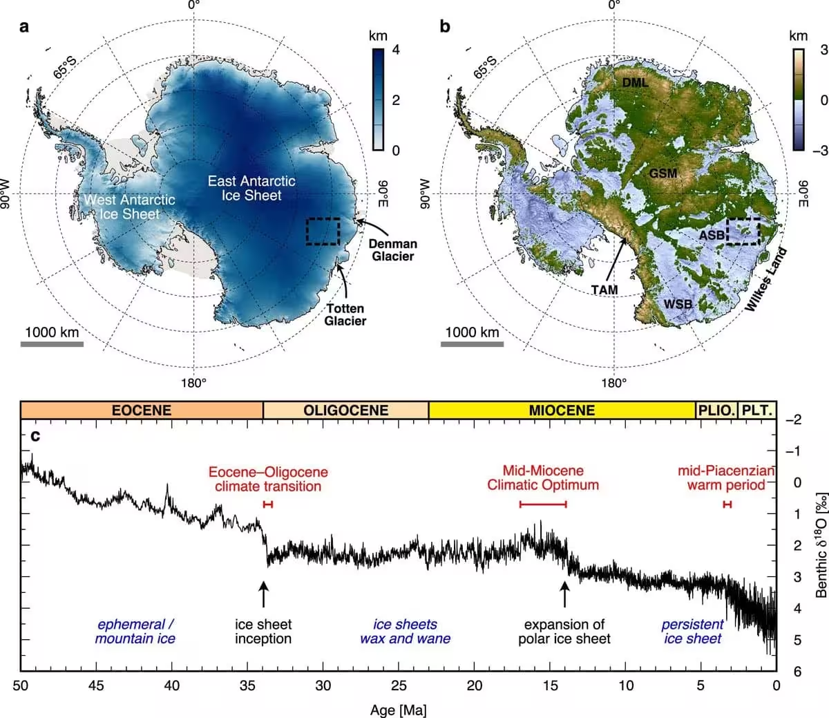
The revealed landscape provides a glimpse into an era when fluvial processes dominated the continent. These river-carved valleys remained relatively undisturbed until the Eocene-Oligocene transition, a period when a dramatic decline in atmospheric carbon dioxide and global temperatures triggered the rapid expansion of the East Antarctic Ice Sheet. High-altitude regions, such as the Transantarctic Mountains and the Gamburtsev Subglacial Mountains, acted as anchor points for the thickening ice, eventually coalescing into the continental shield seen today.
The history of the ice sheet is not one of total permanence, however. Evidence recovered from marine sediments suggests that during warmer intervals, such as the mid-Pliocene and various Pleistocene interglacials, the ice retreated, leaving its own imprint on the geological record.
Implications for Future Climate Modeling
Beyond the geological intrigue, this ancient topography serves as a critical diagnostic tool for modern climate science. By observing how the landscape shaped the ice sheet in the past, scientists hope to better predict how current and future global warming might affect the ice, particularly in vulnerable zones like the Aurora and Wilkes Subglacial Basins.
“Understanding how this massive sheet might respond to human-driven climate change is a pressing concern,” Jamieson explained. The study, detailed in Nature Communications, highlights how the underlying terrain influences the stability of the ice, which has direct consequences for future sea-level rise.
The research team plans to continue surveying the unexplored sections of the continent, aiming to fill the remaining gaps in their map. The objective is to refine a comprehensive understanding of the interplay between the shifting ice sheet and the underlying topography throughout Earth’s deep geological history.
This article has been fact checked for accuracy, with information verified against reputable sources. Learn more about us and our editorial process.
Last reviewed on .
Article history
- Latest version
Reference(s)
- “Professor Stewart Jamieson - Durham University.” <https://www.durham.ac.uk/staff/stewart-jamieson/>.
- Agency, European. “RADARSAT.” <https://earth.esa.int/eogateway/missions/radarsat>.
- Davies, Bethan. “East Antarctic Ice Sheet - AntarcticGlaciers.org.”, March 17, 2013 AntarcticGlaciers.org <https://www.antarcticglaciers.org/antarctica-2/east-antarctic-ice-sheet/>.
- Jamieson, Stewart. “An ancient river landscape preserved beneath the East Antarctic Ice Sheet - Nature Communications.”, vol. 14, no. 1, October 24, 2023, pp. 6507 Nature, doi: 10.1038/s41467-023-42152-2. <https://www.nature.com/articles/s41467-023-42152-2>.
Cite this page:
- Posted by William Moore