Scientists Built an Earth Map Tool That Reveals Where Your Home Was 320 Million Years Ago
Imagine if the area you call home today was once submerged beneath warm tropical waters or stretched across vast, arid deserts. Researchers have now developed an interactive tool that lets you journey back in time to see how Earth’s geography has transformed over millions of years.
A team of Earth scientists led by Utrecht University has developed an innovative online tool that reveals the exact location of any place on Earth hundreds of millions of years ago. By utilizing an advanced geological reconstruction model, the platform empowers users to track the movement of continents and tectonic plates back to the era of Pangea.
The groundbreaking research, published in PLOS One, provides scientists with a significantly more accurate understanding of Earth’s ancient geography. The model holds immense potential for researchers studying climate history, fossils, biodiversity, and the evolution of long-lost continents.
This is crucial because latitude has a profound impact on climate. Scientists attempting to comprehend ancient ecosystems must not only know the age of rocks and fossils but also the location where those rocks originally formed. Previous paleogeographic models attempted this kind of reconstruction, but many lacked detailed information about smaller tectonic plates and fragmented continental blocks.
Unraveling Earth’s Ancient Secrets
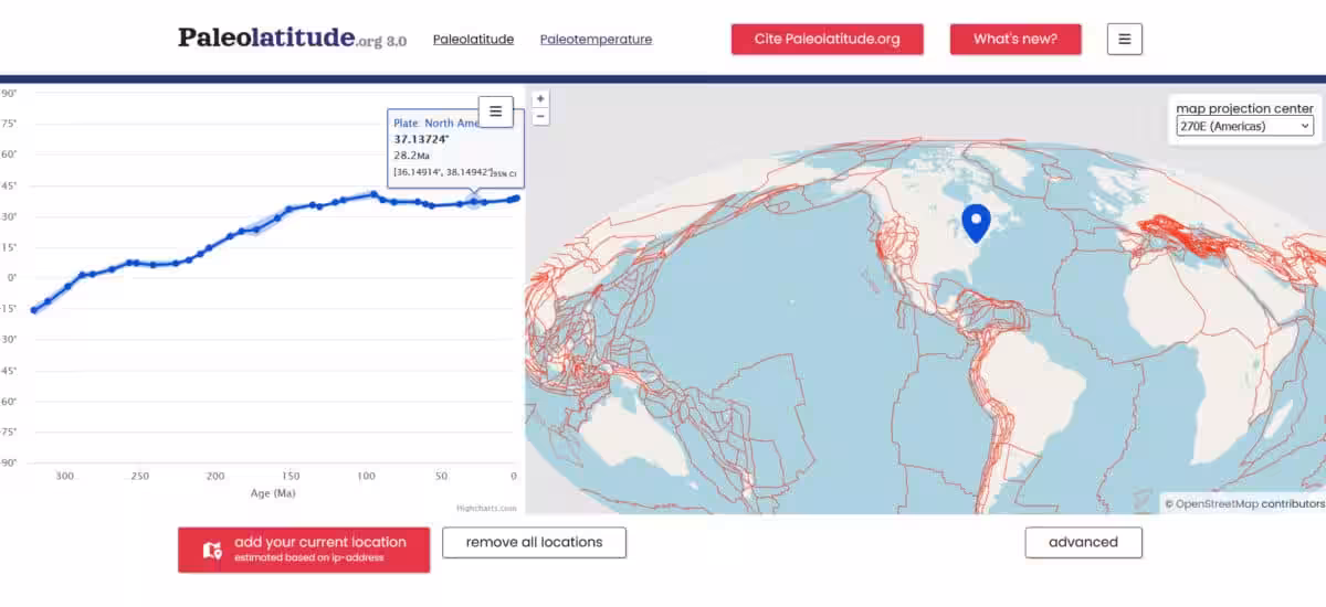
The new platform, Paleolatitude.org, allows users to input any modern location and view its estimated latitude at various points in Earth’s history. The current reconstruction spans 320 million years, covering the formation and breakup of Pangea.
Researchers behind the project explain in PLOS One that the updated model incorporates the movement of smaller tectonic plates as well as “lost continents” that disappeared long ago into Earth’s mantle.
The model includes the movement of Greater Adria, the Tethys Himalayas, and Argoland. Fragments of these ancient landmasses still exist today as folded rock formations inside mountain ranges across the Mediterranean region, the Himalayas, and Indonesia.
Lead researcher Douwe van Hinsbergen stated that the improved reconstruction now enables scientists to connect those rocks to the tectonic plates they originally belonged to before geological processes buried them deep beneath Earth’s surface.
Unlocking the Secrets of Earth’s Magnetic Past
To determine the location of continents millions of years ago, scientists heavily relied on magnetic information stored inside ancient rocks. Many of these rocks contain magnetic minerals that aligned with Earth’s magnetic field at the moment the rocks formed.
“Because the angle formed by Earth’s magnetic field and Earth’s surface changes gradually from the poles towards the equator and is therefore linked to latitude. And many rocks contain magnetic minerals that ‘recorded’ the direction of the magnetic field at that location when the rock was formed. So, using this, we can determine at what latitude such a rock was formed.”
This magnetic information is combined with dating techniques and tectonic reconstructions to rebuild the movement of plates through time. One example highlighted by the Utrecht team involves 245-million-year-old fossils discovered in Winterswijk in the Netherlands. Researchers studying the area found evidence of tropical seas and desert-like conditions similar to those seen around today’s Persian Gulf.
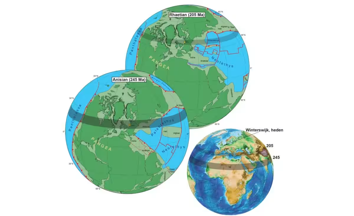
The explanation was geographical rather than purely climatic. Earlier work from the same research group had already shown that the Netherlands occupied latitudes comparable to modern Arabia during that period.
Unlocking the Secrets of Biodiversity
The team believes the reconstruction could become a valuable tool for studying biodiversity and past mass extinctions. Mountain ranges formed by tectonic collisions contain large numbers of fossils, and the improved model helps scientists place those species more accurately within ancient climate zones.
“This allows us, for example, to show what happened to global biodiversity during and after mass extinctions in the past, for instance due to Earth rapidly warming or cooling,” she explained in the university statement.
Future versions of the model are expected to extend even further back in time, eventually reaching the Cambrian explosion around 550 million years ago.
This article has been fact checked for accuracy, with information verified against reputable sources. Learn more about us and our editorial process.
Last reviewed on .
Article history
- Latest version
Reference(s)
- “Paleolatitude.” <https://paleolatitude.org/>.
- Hinsbergen, Douwe. “Paleolatitude.org 3.0: A calculator for paleoclimate and paleobiology studies based on a new global paleogeography model.”, vol. 21, no. 4, pp. e0346817, doi: 10.1371/journal.pone.0346817. <https://journals.plos.org/plosone/article?id=10.1371/journal.pone.0346817>.
- “Douwe J.J. van Hinsbergen – Geologist – Tectonicist.” <https://www.geologist.nl/>.
- “Security verifications.” <https://www.uu.nl/en/news/where-was-your-back-yard-millions-of-years-ago>.
Cite this page:
- Posted by Linda Wilson