Sinking Cities Accelerate Sea Level Rise, New Study Links Human-Driven Land Subsidence
New study finds sinking land dramatically speeds sea‑level rise, endangering the world’s most populated coastal areas.
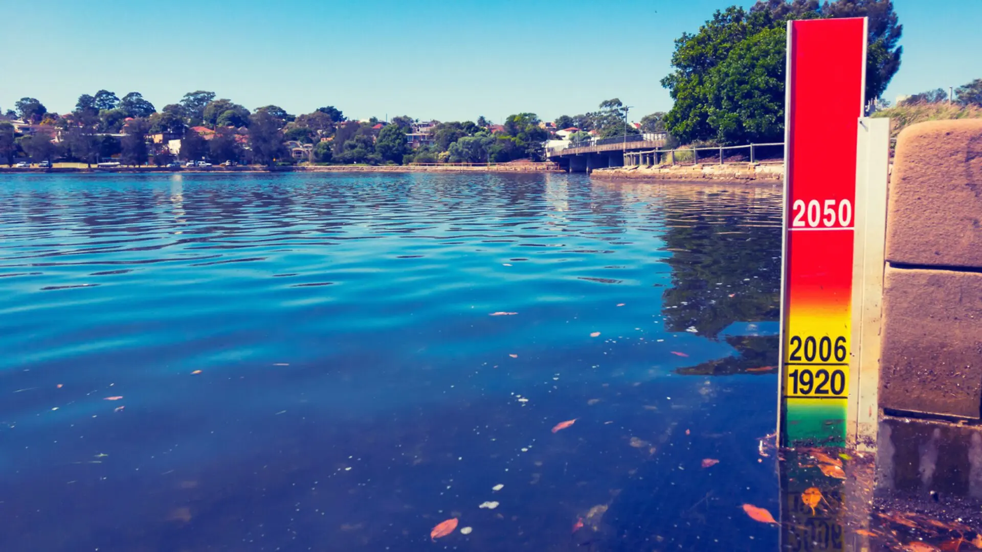
Rising oceans are only half of the story for many megacities on the coast. A recent analysis in Nature Communications shows that the terrain beneath several of the world’s most populated shoreline settlements is sinking, accelerating local sea‑level rise and intensifying flood danger far beyond the global average.
Ground Decline Boosts Coastal Water Levels
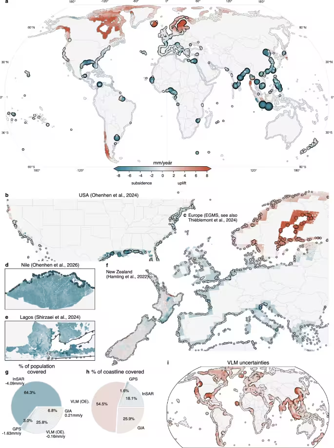
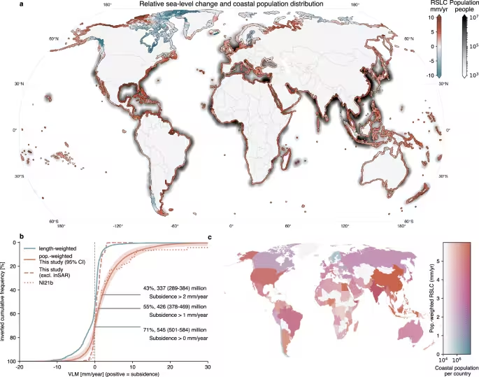
While long‑term monitoring has linked ocean height increases to melting glaciers and thermal expansion, the new work adds a crucial missing piece: vertical land motion. Teams from the German Geodetic Research Institute at the Technical University of Munich (DGFI‑TUM) and Tulane University estimate that heavily built‑up coastal zones are experiencing a combined relative sea‑level rise of roughly 6 mm per year. This rate is almost double the contribution from ocean warming alone and about three times higher than the coastline‑weighted global mean.
The compound effect means that millions of residents are confronting higher water levels above and a subsiding foundation below. The outcome is a surge in flood events, amplified storm surges, steeper infrastructure expenses, and mounting pressure on municipal authorities to devise adaptive measures. Rather than a single driver, the risk emerges from the interplay of natural geological forces and anthropogenic activities, creating a mosaic of challenges that differ from city to city.
Lead author Dr. Julius Oelsmann emphasized the dual nature of the problem: “Accurate sea‑level projections require simultaneous monitoring of the ocean surface and the land it meets. In densely populated shorelines, human‑driven activities—especially intensive water and resource extraction—exacerbate subsidence, while the sheer mass of urban infrastructure further compounds the effect, dramatically magnifying climate‑induced sea‑level rise.”
Anthropogenic Forces Drive Most of the Sinking
The authors identify several mechanisms that lower the ground, each varying in importance across regions. Pumping large volumes of groundwater removes support for sediment layers, allowing the overlying earth to compact. Similar subsidence follows oil and gas extraction, while youthful deltaic sediments naturally compress under their own weight. Rapid city growth adds another burden, as the weight of buildings, roads, and utilities presses down on the crust.
Long‑term geological processes—tectonic shifts and post‑glacial rebound—also affect vertical motion, though they typically unfold over centuries. The combined impact of these factors can make local sea‑level rise appear faster than the global ocean trend, meaning communities may face worsening flood exposure even if the worldwide ocean level stays constant. The study argues that comprehensive risk assessments must therefore track both marine and terrestrial dynamics.
The research, published in Nature Communications, proposes that integrating subsidence data into coastal planning is essential for realistic flood‑risk modeling. By merging satellite imagery, geodetic surveys, and population‑weighted coastal analyses, the authors deliver one of the most detailed global pictures of how sinking terrain reshapes sea‑level projections.
Uneven Sinking Creates Global Hotspots
The analysis uncovers stark regional contrasts. Nations such as Thailand, Bangladesh, Nigeria, Egypt, China and Indonesia register the highest population‑weighted relative sea‑level rise, ranging from 7 to 10 mm per year. The United States, Italy and the Netherlands display intermediate values of roughly 4 to 5 mm annually. On a city scale, Jakarta averages 13.7 mm per year of subsidence, Tianjin 13.5 mm, and Bangkok 8.5 mm. In some Jakarta districts the ground is sinking at an extreme 42 mm per year, while other neighborhoods even show uplift.
Not every coastline is descending. In parts of Sweden and Finland, post‑glacial rebound lifts the land faster than sea levels rise, resulting in a net decline in relative sea level. These divergent trends underscore the necessity of localized measurements for effective adaptation planning.
Managing Water Use Can Slow the Descent
A hopeful insight from the study is that subsidence is not always irreversible. Unlike global sea‑level rise, which hinges on worldwide greenhouse‑gas emissions, many sinking processes can be mitigated through targeted policy. Over‑extraction of groundwater stands out as a primary driver of land lowering in numerous urban areas. Tightening withdrawal regulations, diversifying water supplies, boosting conservation and recharging aquifers can markedly reduce sinking rates.
Historical cases illustrate the potential impact. Tokyo once suffered subsidence exceeding 10 cm per year, with some districts sinking as much as 24 cm annually. After implementing stringent groundwater controls and alternative water sources, the city curbed the trend dramatically. Similar improvements were observed in the Harris‑Galveston region of Texas following decades of water‑management reforms.
“In many large coastal cities, groundwater extraction is a major driver of land subsidence. This means that local political and water‑management decisions can make a significant difference,” said Florian Seitz, Professor of Geodetic Geodynamics and Director of DGFI‑TUM. “Improved groundwater management, stricter regulation of withdrawals, or targeted recharge of aquifers can at least slow subsidence rates and, in some cases, largely halt them.”
The authors conclude that while oceanic rise will continue as the climate evolves, coastal communities retain the ability to lessen one of the fastest‑growing contributors to local flood risk by managing the ground beneath them with the same diligence applied to the water around them.
This article has been fact checked for accuracy, with information verified against reputable sources. Learn more about us and our editorial process.
Last reviewed on .
Article history
- Latest version
Reference(s)
- Oelsmann, Julius. “Subsidence more than doubles sea-level rise today along densely populated coasts - Nature Communications.”, vol. 17, no. 1, May 16, 2026, pp. 4382 Nature, doi: 10.1038/s41467-026-72293-z. <https://www.nature.com/articles/s41467-026-72293-z>.
Cite this page:
- Posted by Mary Johnson