New Global Seismic Model Reveals Hidden Structures Beneath Southern Oceans
By tracking earthquake waves for 3.5 hours instead of one, scientists illuminated deep mantle regions previously hidden by sparse ocean monitoring stations.
Seismologists have mapped previously hidden structures deep beneath the southern hemisphere and vast ocean basins by tracking seismic waves for up to 3.5 hours after major earthquakes. The resulting global model, named RevealLO, overcomes long-standing blind spots caused by sparse seismic monitoring stations in remote oceanic regions.
Earth imaging relies on full-waveform inversion, a high-resolution computational technique that processes entire seismogram records rather than isolated arrival times to reconstruct the planet’s interior. Traditional global models typically truncate seismograms at one hour to save computational costs, which captures direct body waves and minor-arc surface waves but misses major planetary traversals. This limitation leaves the southern hemisphere and oceanic basins poorly illuminated due to a lack of land-based seismometers. To solve this issue, researchers from ETH Zurich and Mondaic Ltd. expanded the recording window to 3.5 hours, incorporating major-arc surface waves and late-arriving multi-orbit body waves that sample the Earth across epicentral distances exceeding 180 degrees. The work is available on the arXiv preprint server, detailing how the team processed data from 1,235 earthquakes that occurred between 1982 and 2026.
How Longer Recording Windows Illuminate the Deep Earth
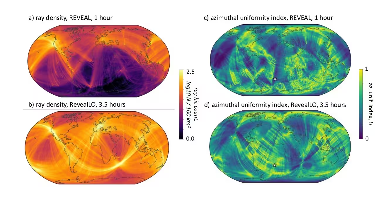
By capturing waves that have traveled around the globe or reflected multiple times through the mantle, the team increased azimuthal ray coverage beneath remote areas like the South Pacific and Southern Oceans. The extended data acquisition provides an azimuthal information gain of 0.5 to 0.7 in regions that previously suffered from sub-parallel ray corridors. This diverse crossing path network prevents unmodeled horizontal crystal alignments from mapping into artificial vertical velocity anomalies.
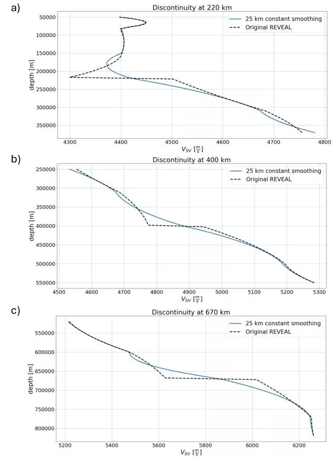
The team simulated three-dimensional viscoelastic wavefields on global cubed-sphere meshes using the Salvus solver, performing iterative optimization across five period bands ranging from 100 to 60 seconds. To ensure the new data drove the structural updates, the researchers smoothed out artificially imposed mantle discontinuities from older reference models and applied a targeted Gaussian taper to remove an inversion artifact located beneath New Zealand.
What the Updated Model Reveals About Mantle Dynamics
Comparing the new model against its predecessor, known as REVEAL, reveals structural updates of 30 to 70 percent of the original anomaly amplitude within the upper mantle and transition zone down to 700 kilometers depth. In the mid-mantle between 1,000 and 1,500 kilometers depth, waveform changes reach roughly 25 percent of baseline anomaly amplitudes, driven primarily by surface wave overtones and multiply reflected body waves like SS and ScS phases.
Validation tests using an independent control set of 54 earthquakes not included in the inversion showed that RevealLO reduces overall waveform misfit by 15.6 percent. Furthermore, forward simulations confirmed that integrating the long-period updates back onto high-resolution baseline meshes preserves short-wavelength features while improving the alignment of complex surface wave overtones.
Methodological Limits and Next Steps
The authors note several technical boundaries in their study. Because fundamental-mode surface wave sensitivity decays exponentially with depth, the enhanced southern hemisphere coverage primarily benefits the upper 400 kilometers of the mantle. Deeper structures rely heavily on body wave multiples, and lower-mantle updates require careful boundary tapering near the core-mantle boundary to suppress artificial velocity oscillations. Future refinements will require explicit parameterization of azimuthal anisotropy to fully resolve complex directional wave speed variations across the mantle.
The study was posted to the arXiv preprint server on November 16, 2026.
This article has been fact checked for accuracy, with information verified against reputable sources. Learn more about us and our editorial process.
Last reviewed on .
Article history
- Latest version
Reference(s)
- Schiller, C.. “RevealLO: Global-Scale FWI Including Long-Period Major-Arc Surface Wave and Multi-Orbit Body Wave Data.” arXiv.org <http://arxiv.org/abs/2611.21322v1>.
Cite this page:
- Posted by Michael Ellison