AI Model Spots Hidden Mountain Landslides in Complex Terrain
An upgraded lightweight computer vision network successfully balances high detection accuracy with efficient hardware deployment for plateau hazard screening.
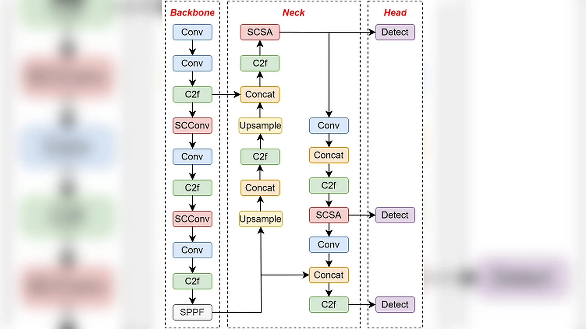
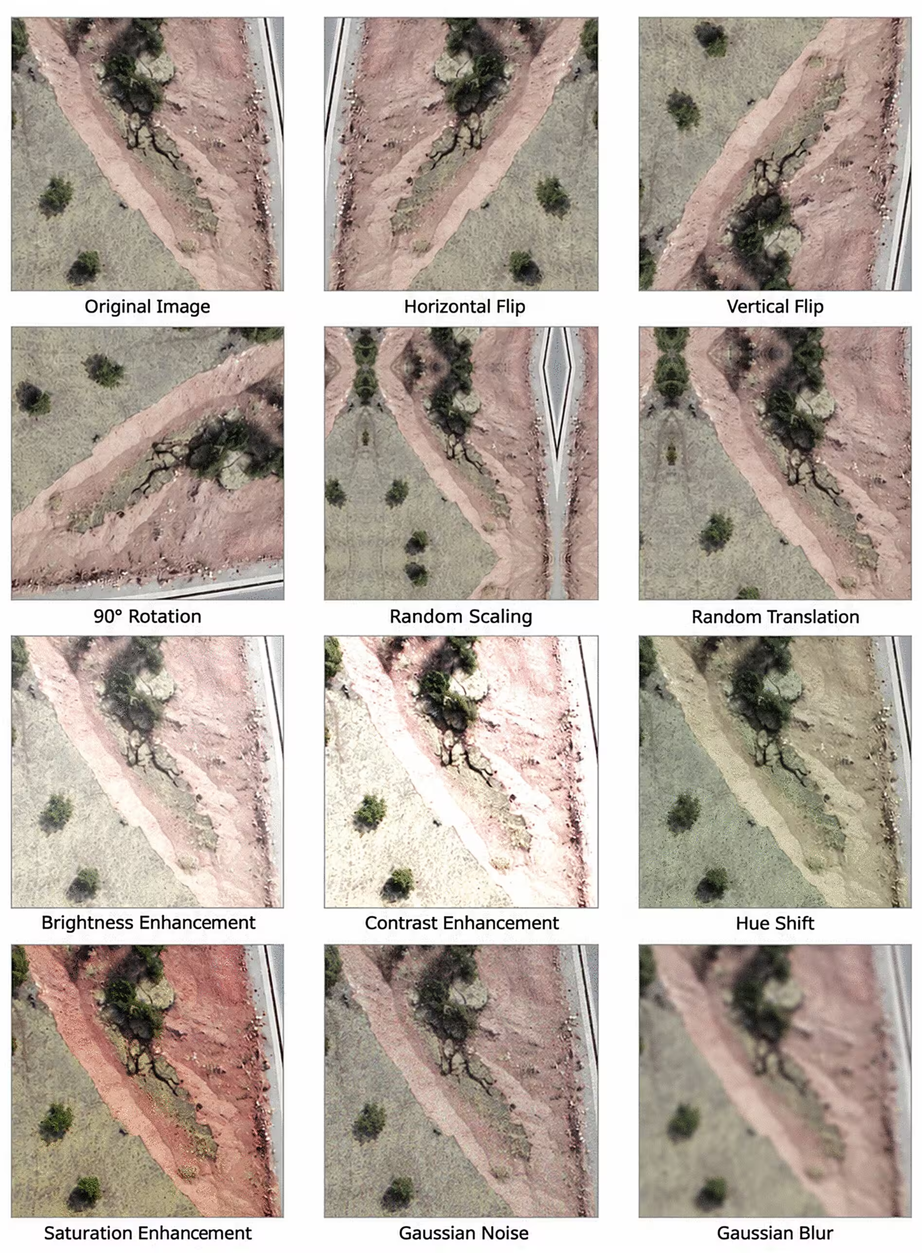
Geological data collected from southwestern China reveal that more than 2,900 satellite and drone images can now be processed by an upgraded artificial intelligence model to identify destructive landslides hidden in rugged plateau terrain. Landslides in these mountainous regions often blend into surrounding bare rock, vegetation, and shadows, making them notoriously difficult for standard automated systems to spot without generating false alarms.
By reworking a standard lightweight computer vision network called YOLOv8n, researchers designed a system that balances high accuracy with low computational demands. The new architecture, detailed published in PLOS One, overcomes background interference and subtle target features that typically confound automated hazard detection tools.
Rebuilding Feature Extraction for Fragmented Terrain
Landslides in plateau canyons exhibit massive scale variations, irregular boundaries, and weak textural details that easily get lost amid dense forests and steep cliffs. To tackle this, the research team introduced a spatial and channel reconstruction convolution module into the network’s backbone to filter out redundant spatial information while preserving fine-grained structural features of small- and medium-scale landslides.
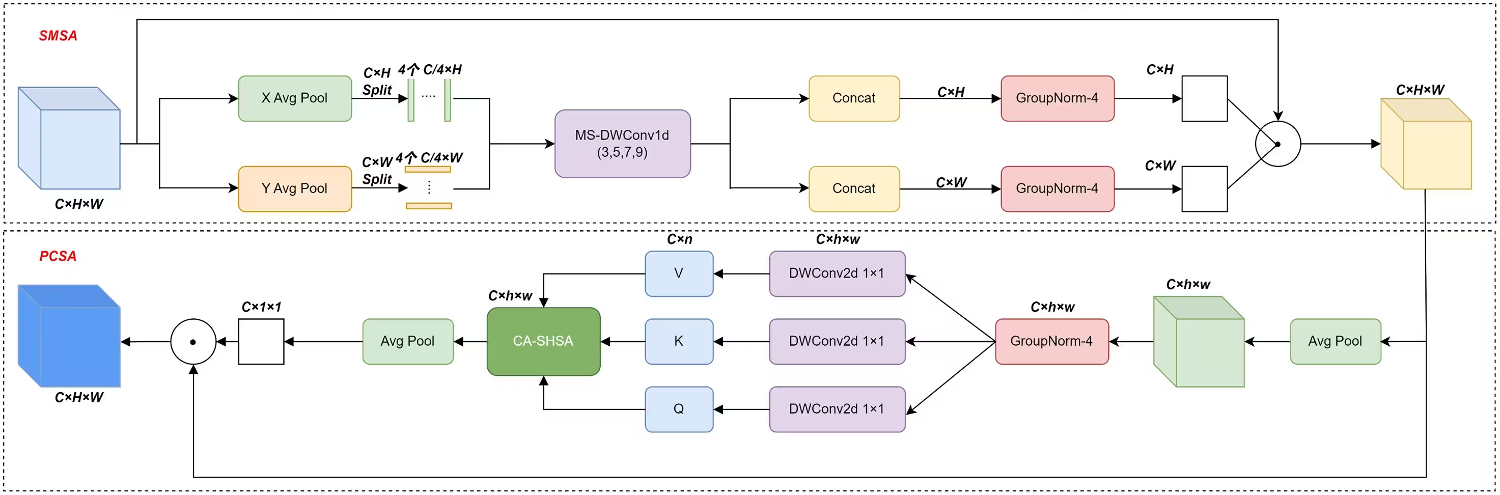
Working alongside this reconstruction step, a spatial and channel synergistic attention mechanism was embedded into the multi-scale feature fusion stage. This attention mechanism acts like a dual filter, amplifying discriminative responses related to landslide contours and surface disturbances while suppressing background noise from vegetation and terrain shadows.
Balancing Hard Samples and Geometric Localization
Identifying sparse landslide targets amidst vast expanses of stable mountainside creates a severe imbalance between positive and negative training samples. Traditional loss functions tend to let easy-to-classify background regions dominate gradient updates, leading to missed detections of concealed hazards.
To correct this, the authors adopted Focal Loss to reduce the weight of easily classified background samples and force the network to focus on hard-to-classify, boundary-blurred targets. Furthermore, they replaced conventional bounding box regression with a specialized loss function designed to handle angular deviation and shape differences, ensuring precise geometric localization of irregularly shaped landslide masses.
Performance Gains Across Diverse Mountainous Scenarios
Evaluating the optimized model on a comprehensive test set demonstrated notable improvements over the baseline YOLOv8n architecture. Precision reached 87.3 percent, recall climbed to 84.0 percent, and the mean average precision metrics at standard and stricter thresholds reached 89.9 percent and 51.4 percent, respectively.
Independent cross-regional tests using high-resolution aerial imagery from Moxi Town in Sichuan and satellite data from Medog in Tibet confirmed that the upgraded model maintains superior transferability across different spatial resolutions and sensor platforms. Grad-CAM heatmap visualizations further verified that the model’s high-attention zones concentrate precisely on actual landslide bodies rather than background artifacts.
Limitations and Future Remote Sensing Integration
Despite these advances, the researchers noted that optical RGB imagery alone remains constrained by physical occlusions such as heavy snow cover, dense tree canopies, or deep canyon shadows that obscure surface textures. Future work will explore fusing multi-source remote sensing data, including digital elevation models and synthetic aperture radar information, to enhance hazard detection under extreme environmental conditions.
The research was published in PLOS One on November 16, 2026.
This article has been fact checked for accuracy, with information verified against reputable sources. Learn more about us and our editorial process.
Last reviewed on .
Article history
- Latest version
Reference(s)
- Wang, Runchi., et al. “CSFS-YOLOv8n: A complex terrain landslide detection model synergistically enhanced by SCConv and SCSA.” PLOS One, vol. 21, no. 11, November 16, 2026, pp. e0361878 Public Library of Science (PLoS), doi: 10.1371/journal.pone.0361878. <https://doi.org/10.1371/journal.pone.0361878>.
Cite this page:
- Posted by Vikram Desai