The Curious Mystery of Null Island
At the exact point where the Equator meets the Prime Meridian lies Null Island, a place that doesn’t exist, yet has a real role in mapping and ocean science.
At the exact point where the Equator meets the Prime Meridian lies a place called Null Island. It’s not an island at all, but it has captured the imagination of geographers, programmers, and oceanographers alike.
Where Exactly Is Null Island?
The coordinates 0°N, 0°E explained
Null Island sits at the intersection of 0 degrees latitude and 0 degrees longitude, a spot in the Gulf of Guinea, off the coast of West Africa. This is the point where the Equator (running east–west) and the Prime Meridian (running north–south) cross.
How to find Null Island on a map or Google Earth
If you type “0,0” into Google Maps or Google Earth, you’ll be taken to a patch of open ocean. The nearest land is over 600 kilometers away, making it one of the most remote coordinate points on Earth.
Is Null Island Real?
The origin of the Null Island myth
Null Island began as a joke among cartographers and GIS (Geographic Information Systems) professionals. In mapping software, when location data is missing or corrupted, the system sometimes defaults to 0°N, 0°E. Over time, this “error location” became known as Null Island.
Which country “owns” Null Island?
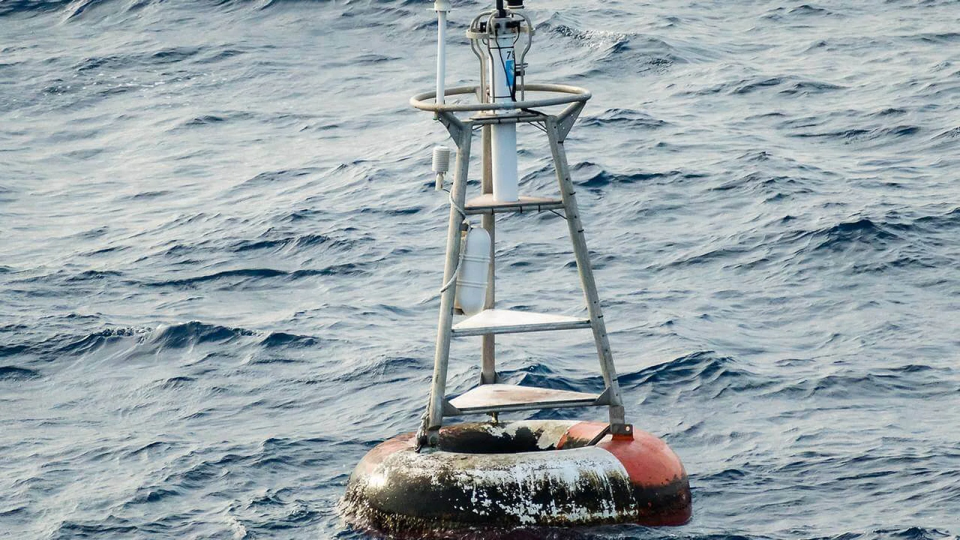
No country owns Null Island, it’s in international waters. However, the United States’ NOAA (National Oceanic and Atmospheric Administration) maintains a weather buoy there for ocean monitoring.
Fascinating Facts About Null Island
The NOAA weather buoy at 0,0
The only real object at Null Island is Station 13010, a weather buoy that collects data on wind, temperature, and ocean currents. This information helps scientists study climate patterns.
The fictional flag and culture of Null Island
The geospatial community has embraced Null Island with humor, creating a fictional flag, coat of arms, and even a “national anthem.” It’s a playful way to humanize a technical concept.
Why mapmakers love this imaginary place
Null Island is a reminder of how digital maps work—and how they sometimes fail. It’s also a teaching tool for explaining coordinates, data errors, and the importance of accurate geolocation.
In short: Null Island may not exist physically, but it’s a real landmark in the digital mapping world. It’s where geography, technology, and a bit of humor meet—right at 0°N, 0°E.
This article has been fact checked for accuracy, with information verified against reputable sources. Learn more about us and our editorial process.
Last reviewed on .
Article history
- Latest version
- Last updated by Dayyal Dungrela, MLT, BSc, BS
Reference(s)
- Onge, Tim St.. “The Geographical Oddity of Null Island.”, 22 April 2016 Library of Congress <https://blogs.loc.gov/maps/2016/04/the-geographical-oddity-of-null-island>.
Cite this page:
- Posted by Zara Tariq