Six-Year Study Reveals How Ocean Shifts Drive Amberjack Migration
Satellite data and historical fishing records illuminate the monthly habitat dynamics of greater amberjack in the Taiwan Strait, offering new tools for sustainable marine management.
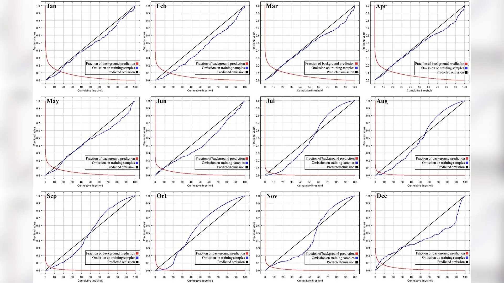
In the dynamic waters of the Taiwan Strait, the greater amberjack (Seriola dumerili) shifts its distribution dramatically across seasons, tracking a changing mosaic of ocean temperatures and current boundaries. A team of researchers has mapped these monthly habitat dynamics using six years of historical fishing data paired with satellite observations, revealing how shifting ocean conditions dictate where this prized pelagic predator thrives. The study, published in iScience, demonstrates that environmental variables such as sea surface height and sea surface temperature control the monthly presence of the species across the marine corridor.
How Seasonal Ocean Shifts Dictate Amberjack Habitats
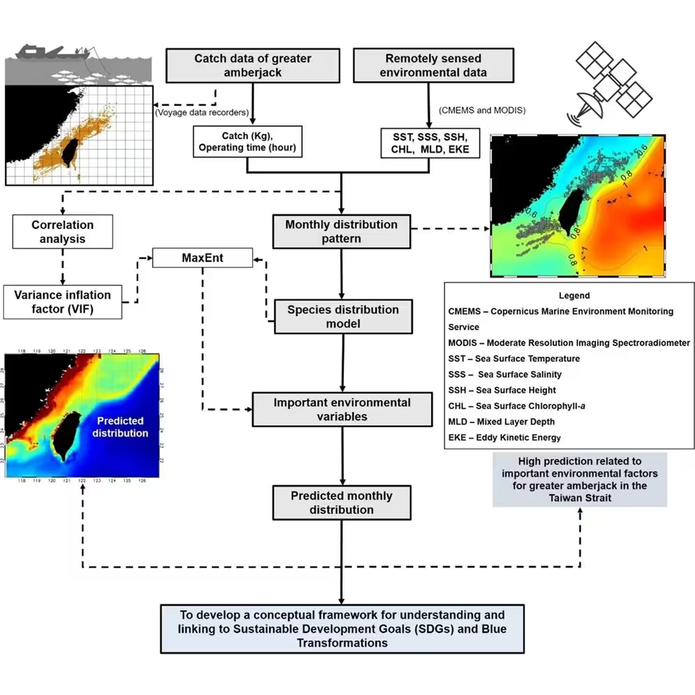
Marine environments are rarely static, and the Taiwan Strait serves as a complex mixing ground influenced by the Kuroshio current and monsoonal winds. By analyzing voyage data recorders from Taiwanese vessels operating between 2014 and 2019, the authors modeled monthly habitat suitability indices to understand the ecological drivers behind greater amberjack distributions. The findings indicate that the primary environmental contributors shift throughout the year. Sea surface height and mixed layer depth exert the greatest influence during the winter and spring months, whereas sea surface temperature and sea surface salinity take over as dominant predictors during the summer.
During the cooler months of January and February, suitable habitats appear relatively fragmented and confined to the western and southern waters of Taiwan. As spring arrives, warming waters and frontal systems trigger a substantial expansion of favorable areas. Habitat suitability reaches its maximum spatial extent and intensity between May and August, forming a continuous band of high suitability stretching from the strait into northeastern waters. By late autumn and early winter, cooling temperatures and intensified monsoon winds cause these favorable zones to contract once more toward the southern shelf regions.
The Environmental Variables Shaping Pelagic Life
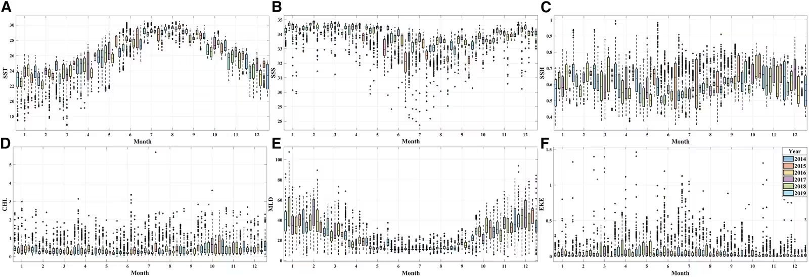
To pinpoint what drives these migrations, the researchers evaluated variables including sea surface temperature, sea surface salinity, sea surface height, chlorophyll-a concentration, mixed layer depth, and eddy kinetic energy. The response curves generated by their models highlight specific physiological preferences for the species. Optimal sea surface temperatures typically ranged from approximately 19 degrees Celsius to 31 degrees Celsius, with preferences shifting toward cooler limits in winter and warmer values in summer. Similarly, sea surface salinity showed a stable preference between 31.5 and 35 PSU, indicating a tolerance for moderate salinity fluctuations while favoring stable oceanic conditions.
Mesoscale oceanographic features, represented by sea surface height and eddy kinetic energy, also play a crucial role in aggregating prey and enhancing foraging efficiency. The models showed that greater amberjack occurrences are closely associated with areas of moderate sea surface height and lower eddy kinetic energy, suggesting that excessive turbulence disrupts habitat stability. Meanwhile, mixed layer depth variations reflect seasonal stratification, helping to drive nutrient entrainment from subsurface waters and stimulating primary productivity during transitional periods.
Bridging Ecological Models with Sustainable Fisheries Management
The ability to predict monthly habitat suitability holds significant value for marine resource management and the pursuit of global sustainability targets. By integrating species distribution modeling with frameworks like United Nations Sustainable Development Goal 14, which focuses on conserving marine resources, researchers hope to guide more effective spatial and temporal management. The monthly maps generated in this study can support dynamic management tools, such as temporary spatial closures during peak aggregation periods or targeted fishing advisories that help fleets locate productive grounds while protecting vulnerable habitats.
Despite these advances, the authors note certain limitations inherent to fishery-dependent datasets. Because the occurrence records rely on commercial fishing locations, the data may inherently reflect human fishing effort and vessel accessibility alongside ecological preferences. Future research incorporating finer-scale environmental monitoring and direct prey distribution data will help refine these predictive models, offering a clearer pathway toward resilient marine ecosystems and sustainable fisheries under a changing climate.
The research was published in iScience on October 29, 2026.
This article has been fact checked for accuracy, with information verified against reputable sources. Learn more about us and our editorial process.
Last reviewed on .
Article history
- Latest version
Reference(s)
- Mammel, Mubarak., et al. “Mapping the monthly habitat dynamics of greater amberjack using MaxEnt model in the Taiwan Strait: Implications for sustainable blue transformations.” iScience, vol. 29, no. 11, November 1, 2026, pp. 118009 Elsevier BV, doi: 10.1016/j.isci.2026.118009. <https://doi.org/10.1016/j.isci.2026.118009>.
Cite this page:
- Posted by Divya Iyer