NASA Unveils Massive 360° Mars Views Captured by Two Rovers Miles Apart
NASA has unveiled a series of expansive, new panoramas of Mars, offering a simultaneous glimpse into distant terrains that appear as if they’re positioned side by side.

NASA has unveiled two breathtaking panoramas captured by its Curiosity and Perseverance rovers, offering a glimpse into the Red Planet’s transformative evolution. These stunning visuals, crafted from hundreds of images, reveal the intricate dance of water, geology, and time on Mars’ surface, allowing scientists to reconstruct the planet’s ancient past.
As these two missions operate on opposite sides of the planet, they share a common goal: unraveling the mystery of whether Mars once harbored life. Data released by NASA’s Jet Propulsion Laboratory (JPL) highlights the significance of these landscapes as natural records, where rock layers and mineral formations preserve evidence of ancient environments.
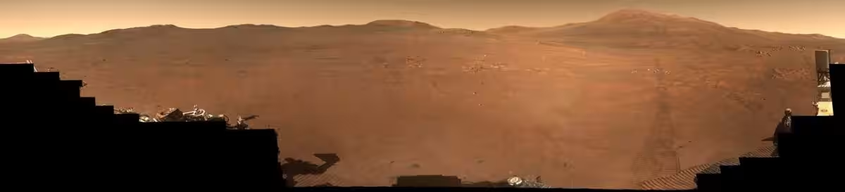
Perseverance Unveils the Secrets of an Ancient Lake
The panorama captured by Perseverance focuses on the “Lac de Charmes” region, situated near the rim of Jezero Crater. This mosaic, comprising 980 images taken between December 18, 2025, and January 25, 2026, showcases terrain shaped by ancient water, including layered rocks and scattered boulders that once formed part of a lake and river delta.
This region is considered a prime location in the search for past life, with some of the rocks visible in the panorama dating back billions of years. During this period, Mars was still developing its crust and experiencing frequent asteroid impacts. In a NASA video released alongside the images, scientists describe the area as a “time capsule” from the earliest stages of the solar system, underscoring its scientific value.
Curiosity Uncovers Evidence of Underground Water
On the other side of the planet, Curiosity continues its exploration of Gale Crater, along the slopes of Mount Sharp. Its latest panorama, comprising 1,031 images captured between November 9 and December 7, 2025, reveals a network of ridges known as “boxwork” formations.
These structures formed when groundwater once moved through fractures in the bedrock, depositing minerals that later resisted erosion. Information shared by NASA explains how this process created the grid-like patterns visible today. Over nearly 15 years on Mars, Curiosity has also identified carbonate minerals such as siderite.
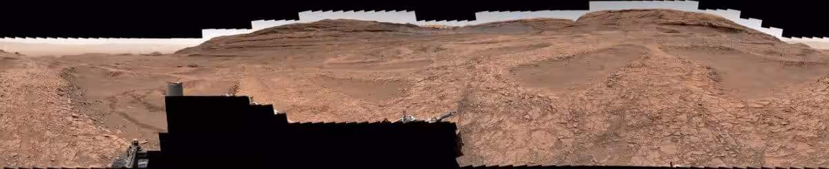
“Scientists had long suspected that carbonate minerals such as siderite formed when carbon dioxide dissolved into ancient lakes, but such deposits had only rarely been found,” the NASA press release stated.
Two Landscapes That Reveal Something Unexpected
The two panoramas, taken about 2,345 miles (3,775 kilometers) apart, offer a unique opportunity for scientists to compare regions shaped by surface water with those influenced by subsurface processes. Reporting by Space.com highlights the significance of these discoveries, which will continue to unravel the secrets of Mars.
“Both missions are looking forward to the next discoveries as they continue to explore the Red Planet. Curiosity has left the boxwork region behind as it continues to explore a mountain layer enriched in salty minerals called sulfates; Perseverance will keep heading toward locations that hold exceptionally old terrain,” NASA scientists said.
This article has been fact checked for accuracy, with information verified against reputable sources. Learn more about us and our editorial process.
Last reviewed on .
Article history
- Latest version
Reference(s)
- Mathewson, Samantha. “NASA's Curiosity and Perseverance rovers capture sweeping Mars panoramas (video).”, May 1, 2026 Space <https://www.space.com/astronomy/mars/nasas-curiosity-and-perseverance-rovers-capture-sweeping-mars-panoramas-video>.
Cite this page:
- Posted by Aisha Ahmed