Advanced Downhole Sensors Reveal Subsurface Geology Without Pulling Core Samples
A new review evaluates how emerging geophysical and spectroscopic tools could soon replace traditional diamond drilling with real-time subsurface data.
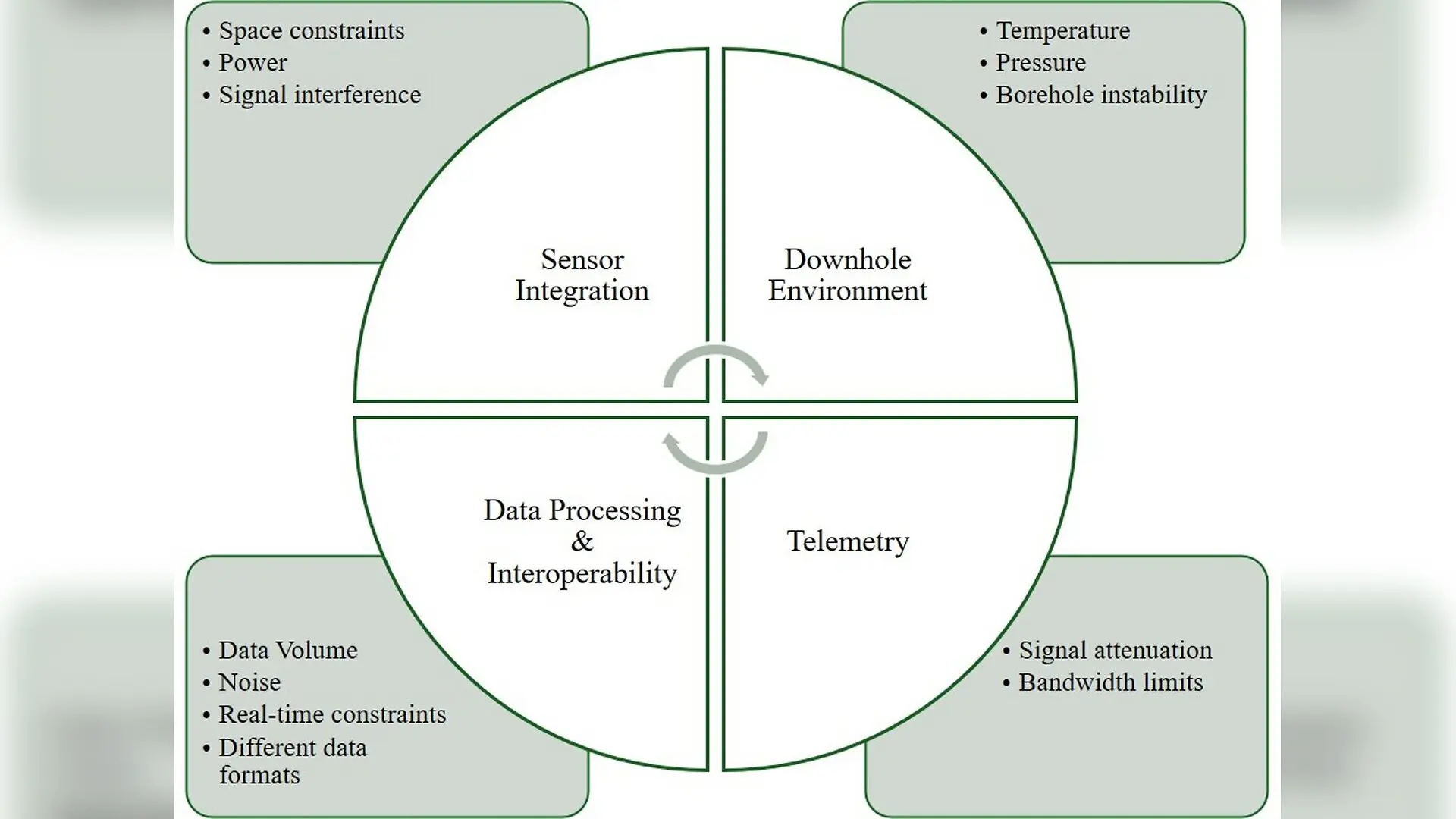
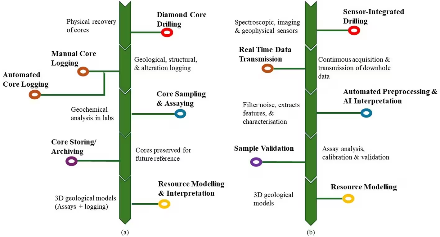
Extracting physical core samples from deep underground has long served as the fundamental standard for understanding mineral deposits, but rising extraction costs and dwindling shallow ore bodies are forcing a major rethink. Traditional diamond drilling operations are notoriously slow, energy-intensive, and account for roughly half of typical mineral exploration budgets while yielding only one-dimensional information along a single borehole. A comprehensive review published in Discover Minerals evaluates how emerging downhole sensor technologies could soon transform subsurface characterization by gathering high-resolution geological and geochemical data in real time as drilling progresses.
How Downhole Sensors Map the Subsurface Without Pulling Core Samples
The transition from post-drilling analysis to real-time downhole sensing relies on a suite of sophisticated spectroscopic, imaging, and geophysical tools adapted for harsh subterranean environments. X-ray fluorescence, commonly known as XRF, measures the wavelengths and intensities of X-rays emitted by a sample to provide rapid elemental composition profiles along a borehole. Similarly, laser-induced breakdown spectroscopy utilizes energetic laser pulses to vaporize tiny amounts of material and create an ionized plasma, generating detailed multi-element geochemical data with minimal sample preparation. Meanwhile, gamma ray spectrometry detects natural radioactive decay to map lithological boundaries and identify alteration zones associated with valuable mineral deposits.
Other established methods include neutron-based geophysical techniques, which bombard the surrounding rock with high-energy neutrons to evaluate elemental concentrations and grade distributions in both dry and fluid-filled boreholes. For structural analysis, acoustic televeyors emit ultrasonic pulses to map fracture networks and borehole geometry, operating effectively even in opaque or muddy drilling fluids where traditional optical cameras fail. More advanced geophysical configurations, such as borehole transient electromagnetic methods and ground-penetrating radar, probe deep into the surrounding rock mass to detect conductive sulfide ore bodies and resistive structural boundaries.
What Holds Real-Time Sensor Integration Back in Mineral Exploration?
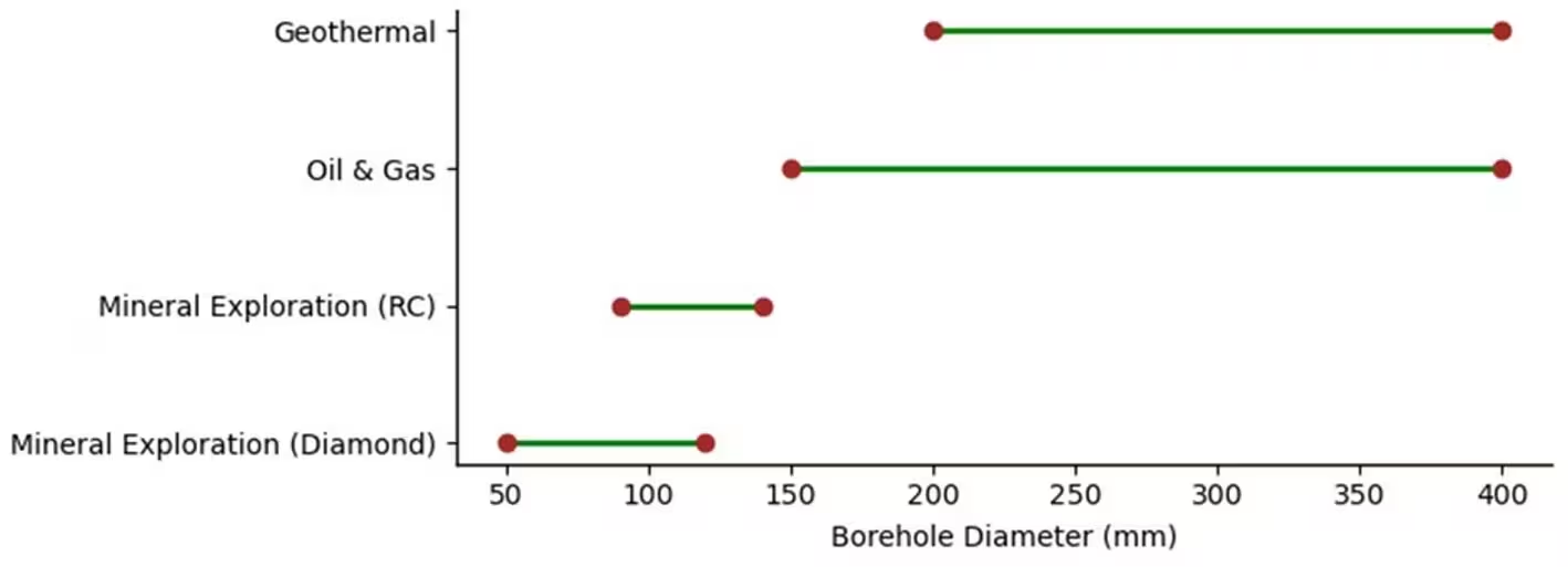
Despite their proven utility in the oil and gas sector, deploying these sensors directly inside active mineral exploration boreholes remains a formidable engineering challenge. Mineral exploration holes are considerably narrower than oil wells, typically measuring between 50 and 120 millimeters in diameter, leaving very little space for sensitive electronics. Furthermore, downhole equipment must endure intense mechanical vibrations, abrasive rock cuttings, high temperatures, and extreme pressures that can quickly degrade hardware performance and ruin optical paths.
Data telemetry presents another major bottleneck for real-time operations, as transmitting massive volumes of multi-sensor data up from the bottom of a deep borehole requires robust communication infrastructure. While the petroleum industry relies on mud-pulse telemetry or wired drill pipes, these systems face severe limitations when scaled down to fit narrower mineral exploration setups. Additionally, different sensors generate heterogeneous data formats, varying spatial resolutions, and conflicting depth references, making seamless data integration into a unified geological framework exceptionally difficult.
Can Machine Learning Automate Complex Geological Interpretations?
To make sense of the overwhelming influx of multi-modal data generated by integrated sensor arrays, researchers are increasingly turning to artificial intelligence and machine learning algorithms. Supervised learning architectures such as convolutional neural networks and recurrent neural networks excel at automated lithological classification, pattern recognition, and mineral mapping. By processing complex geochemical logs and continuous seismic measurements from seismic-while-drilling systems, these computational frameworks can instantly categorize rock types and flag mineralized zones without human bias.
What Happens Next for Smart Exploration Frameworks?
Experts emphasize that downhole sensing technologies are not yet ready to completely replace traditional diamond core drilling, particularly given strict regulatory requirements for verifiable physical evidence under reporting standards like NI 43-101 and the JORC Code. Instead, these innovations will serve a powerful complementary role by providing continuous predictive feedback, guiding adaptive drilling decisions, and allowing geologists to selectively target core collection only where uncertainty is highest. Future progress will depend heavily on establishing standardized data workflows, miniaturizing sensor packages, and conducting large-scale field trials to build absolute confidence among industry stakeholders and investors.
The research was published in Discover Minerals on November 6, 2026.
This article has been fact checked for accuracy, with information verified against reputable sources. Learn more about us and our editorial process.
Last reviewed on .
Article history
- Latest version
Reference(s)
- Senjoba, Lesego., et al. “Emerging downhole sensing technologies for mineral exploration.” Discover Minerals, vol. 3, no. 1, November 6, 2026 Springer Science and Business Media LLC, doi: 10.1007/s44346-026-00023-w. <https://doi.org/10.1007/s44346-026-00023-w>.
Cite this page:
- Posted by Nida Rehman