Highway Weaving Zones Hide a Dangerous Flaw That Standard Safety Scores Completely Miss
Aerial drone data reveals that traditional motion metrics fail to detect close-call traffic conflicts in busy highway merging lanes.
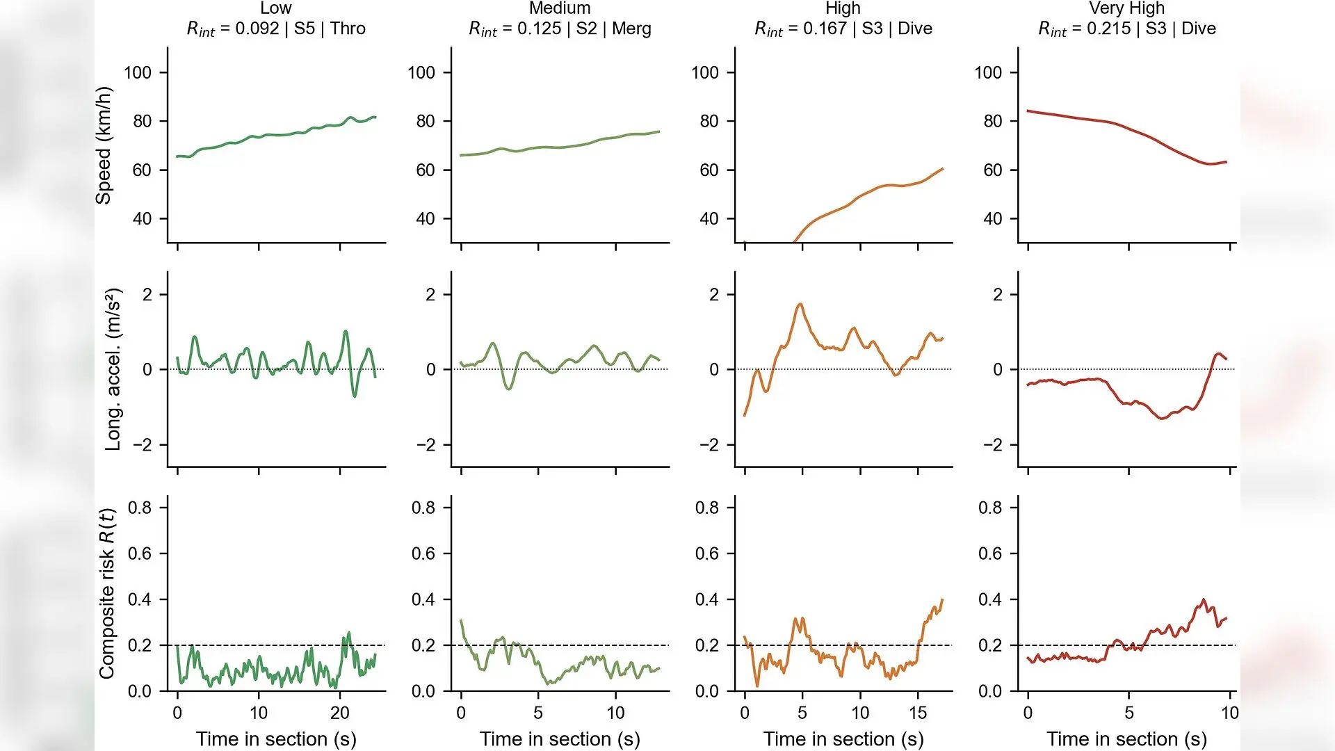
Drivers changing lanes on crowded highway weaving zones face a hidden safety trap where common speed-based evaluations miss three times as many close-call incidents as direct vehicle tracking. Researchers analyzing 12,256 complete vehicle movements captured by aerial drones revealed that standard motion metrics and actual crash risks often point in opposite directions.
Why Traditional Driving Risk Scores Can Be Misleading
For decades, traffic engineers evaluated highway safety by monitoring single-vehicle kinematics, which measures how abruptly a car accelerates, brakes, or swerves. These motion indicators are popular because scientists can compute them for any vehicle without needing to identify nearby traffic pairs. However, a driver maintaining a smooth path at high speed while boxed in by surrounding vehicles will register a pristine safety score on a kinematic monitor, despite skating dangerously close to a multi-car pileup.
To test what these different metrics actually detect, researchers evaluated thousands of drone trajectories published in PLOS One. The team examined seven distinct highway weaving sections, which are critical transition zones where entering and exiting drivers must cross paths across limited asphalt. By running the same vehicle paths through both a motion-based risk formula and a proximity-based conflict measure, the authors uncovered a major disconnect in how road safety is quantified.
The Hidden Trap of Cumulative Exposure Length
A major flaw uncovered in the study involves cumulative risk, a widely used metric that integrates instantaneous risk over the entire time a vehicle spends traversing a zone. Because this metric adds up stress over time, longer highway segments naturally accumulate higher risk scores simply because the trip takes longer. In this dataset, traversal time correlated with section length at an astonishing 0.989, meaning cumulative risk primarily measures asphalt length rather than actual danger.
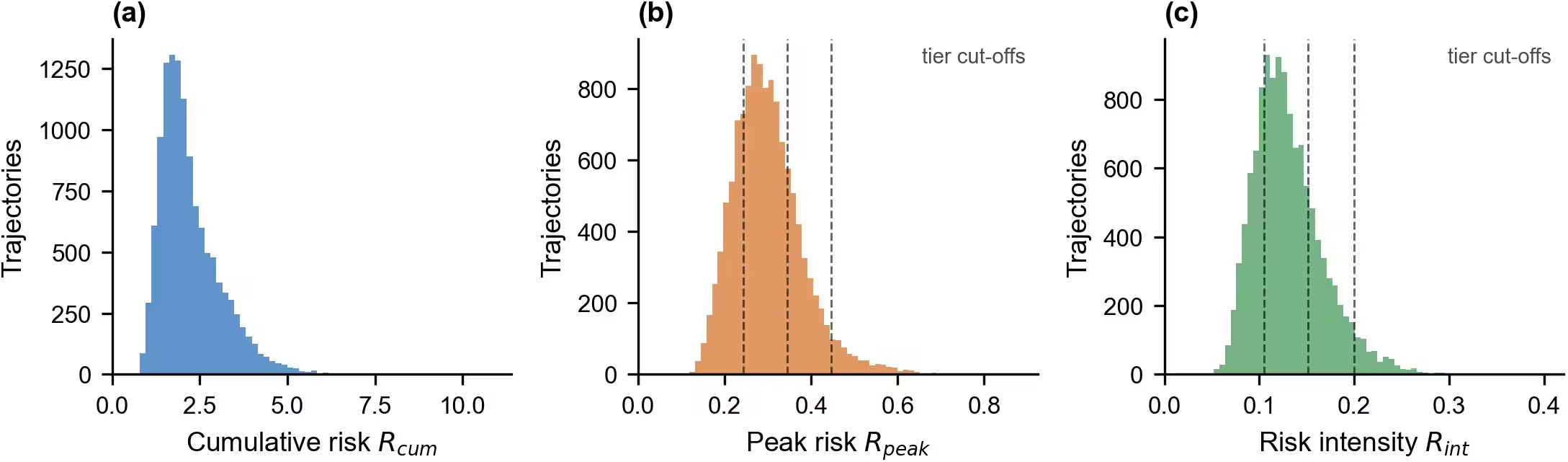
When the authors switched to a time-averaged intensity score to neutralize the length bias, the relationship flipped entirely. Drivers entering the weaving zones at higher speeds accumulated less total risk simply because they spent less time exposed to the hazard, yet their instantaneous risk per second actually increased by 12.7 percent.
How Task Complexity Drives Real Conflict Rates
The two measurement systems also diverged wildly when evaluating facility design. The researchers measured task complexity by calculating the proportion of merging and diverging vehicles crowding the lanes. Sections with high complexity generated close-call conflict rates between 2.4 percent and 3.6 percent, compared to less than 1.5 percent for simpler layouts.
Crucially, kinematic motion scores failed to register this complexity entirely. If a municipality relied solely on motion sensors, a highly complex weaving section packed with merging traffic would look completely benign. Only direct time-to-collision tracking, which calculates how quickly two vehicles would collide if they maintained their current speeds, accurately captured the danger imposed by traffic density.
What This Means for Heavy Vehicles and Future Road Design
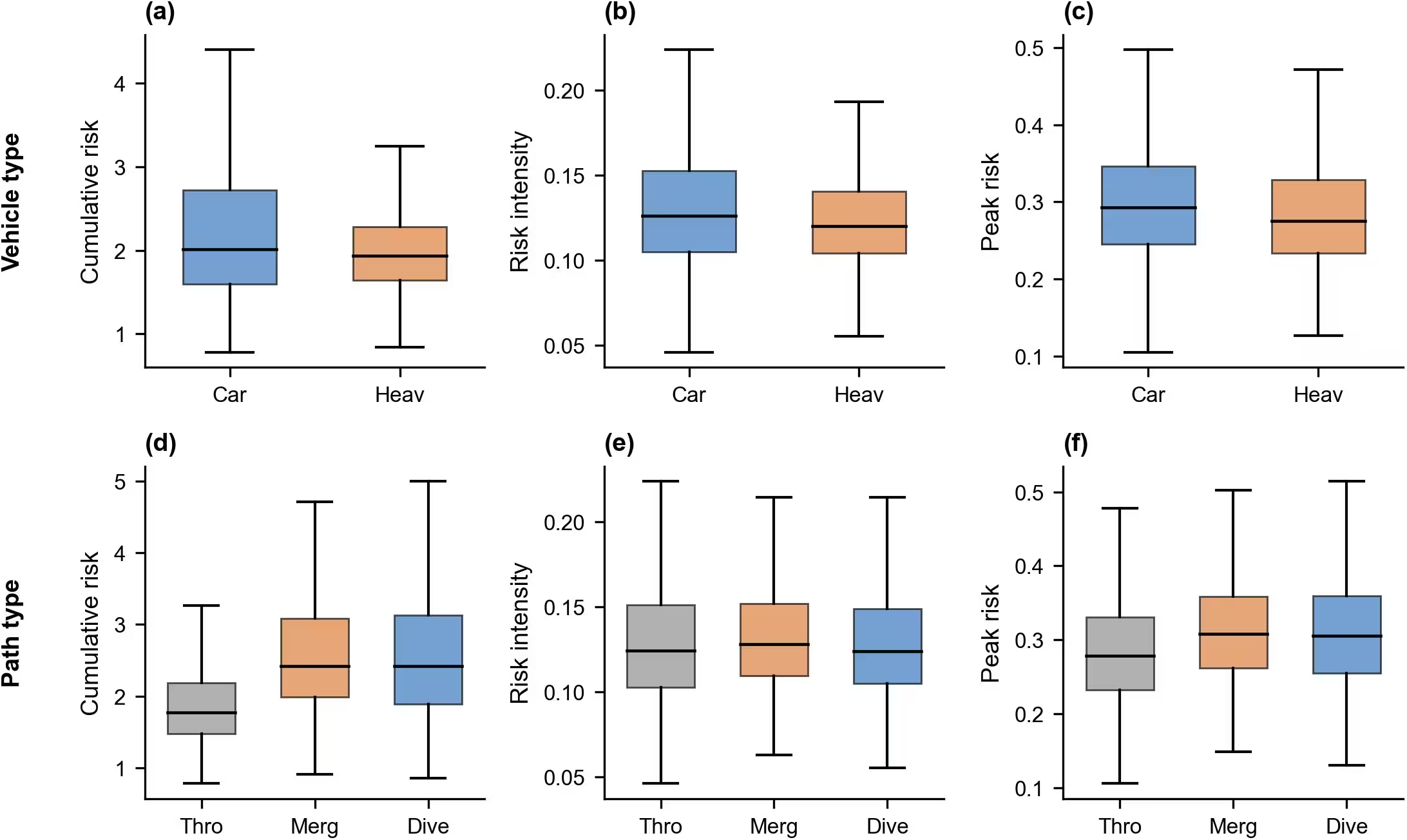
The choice of metrics even changed the verdict on heavy trucks and buses. Kinematic indicators showed heavy vehicles behaving more safely or more dangerously depending entirely on arbitrary normalization constants chosen by the researchers. However, the direct interaction measure, which requires no such tuning, revealed that heavy vehicles engaged in fewer close-call conflicts than passenger cars.
The authors note that the study is limited by its sample size of just seven highway sections, meaning some regional statistical associations require larger multi-site validations. Ultimately, the findings suggest that highway planners should stop relying on single-vehicle motion indicators alone, and instead incorporate direct vehicle-to-vehicle proximity tracking to design safer merging zones.
The research was published in PLOS One on November 5, 2026.
This article has been fact checked for accuracy, with information verified against reputable sources. Learn more about us and our editorial process.
Last reviewed on .
Article history
- Latest version
Reference(s)
- Huang, Zhenghua., et al. “Microscopic risk assessment of highway weaving sections based on large-scale UAV trajectory data: What kinematic and interaction measures each detect.” PLOS One, vol. 21, no. 11, November 5, 2026, pp. e0361559 Public Library of Science (PLoS), doi: 10.1371/journal.pone.0361559. <https://doi.org/10.1371/journal.pone.0361559>.
Cite this page:
- Posted by Deepak Malhotra