A Student Searched a Dataset on a Hard Drive and Found a Massive Lost Maya City Hidden Beneath the Jungle
Lost ancient city unearthed in scanned datasets after years hidden in plain sight
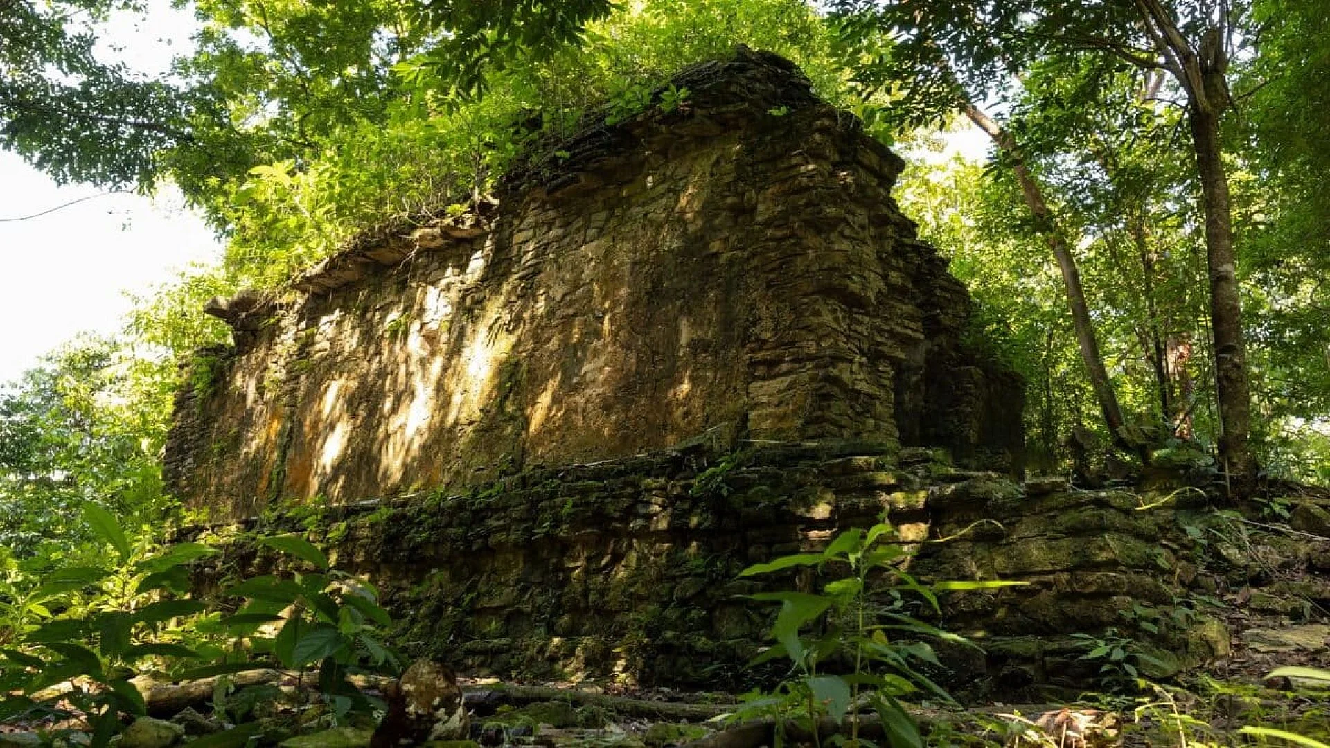
A massive Maya settlement concealed beneath the eastern Campeche rainforest has finally emerged, not from a trek through the jungle but from a fresh look at legacy lidar data originally gathered for a different mission. The site, now referred to as Valeriana, sat unnoticed in a 2013 environmental mapping project for more than ten years.
Published in Antiquity, the research highlights both the scale of the city and the unconventional way it was revealed. Instead of field‑based discovery, the team mined a digital archive that had been publicly accessible for years.
While lidar has reshaped Maya archaeology over the past decade by exposing settlements hidden under thick foliage, Valeriana suggests that future breakthroughs may arise from revisiting existing datasets rather than launching fresh surveys.
Student’s Online Search Uncovers Hidden Metropolis
The key insight came from Luke Auld‑Thomas, then a Ph.D. candidate at Tulane University. While browsing the web, he stumbled upon a 2013 lidar campaign carried out by a Mexican conservation group focused on forest and carbon monitoring.
“I was on something like page 16 of Google search and found a laser survey done by a Mexican organisation for environmental monitoring,” he said.
According to the Antiquity article, the dataset was never meant for archaeological purposes. After applying archaeological processing methods, Auld‑Thomas identified patterns that could not be explained by natural terrain alone.
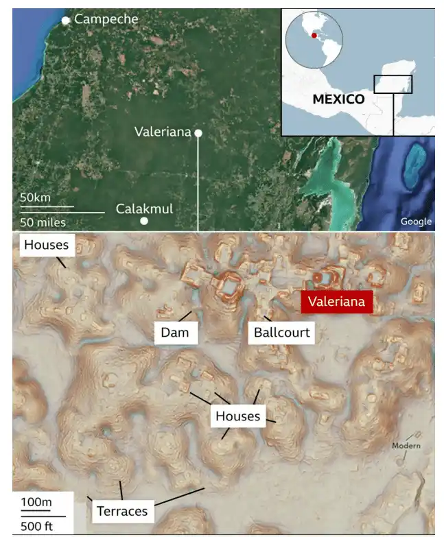
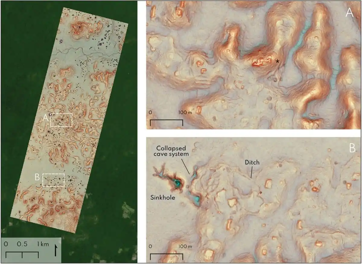
Lidar operates by sending hundreds of thousands of laser pulses from an aircraft; some beams penetrate canopy gaps and strike the ground. Once the vegetation layer is stripped away digitally, ancient constructions become apparent. The 2013 survey spanned roughly 122 square kilometres and mapped 6,764 structures, averaging about 55 buildings per square kilometre. The resulting image pointed to a major Maya urban centre concealed beneath the trees.
Features of the Discovered Maya Urban Center
The lidar visualisation displayed hallmark elements of a Classic Maya city. Researchers distinguished two monumental precincts, expansive enclosed plazas linked by a wide causeway, temple pyramids, a ballcourt, and a reservoir formed by damming a seasonal stream.
Data cited by BBC suggest that the settlement may have supported between 30,000 and 50,000 people at its height between 750 and 850 AD. Those estimates derive from building density rather than direct excavation evidence.
The original Maya name for the settlement has not survived. Scholars have adopted the label Valeriana, drawn from a nearby lagoon, in an area where Maya remains have been noted for many years.
In comments referenced by the source material, Auld‑Thomas said the discovery confirmed expectations rather than overturning existing ideas about the region.
Implications of Re‑examining Existing Lidar Records
The lidar dataset had been publicly available for years before archaeologists applied a heritage‑focused lens. The authors argue that lidar is routinely gathered for forestry, agriculture, conservation, mining and infrastructure projects, yet much of it never reaches specialists who might spot buried cultural features.
Valeriana is distinctive because the survey was intended for environmental monitoring, not for locating ancient ruins. Its reinterpretation demonstrates how data collected for one purpose can yield breakthroughs in another field.
Field verification remains on the agenda. While lidar can outline structures and infrastructure, only on‑the‑ground investigations can establish occupation dates and integrate the site into broader Maya historiography.
“I’ve got to go to Valeriana at some point. It’s so close to the road, how could you not? But I can’t say we will do a project there,” stated Auld‑Thomas. “One of the downsides of discovering lots of new Maya cities in the era of Lidar is that there are more of them than we can ever hope to study.”
This article has been fact checked for accuracy, with information verified against reputable sources. Learn more about us and our editorial process.
Last reviewed on .
Article history
- Latest version
Reference(s)
- “Luke Auld-Thomas - Profile on Academia.edu.” Academia.edu <https://nau.academia.edu/LukeAuldThomas>.
- Auld-Thomas, Luke. “Running out of empty space: environmental lidar and the crowded ancient landscape of Campeche, Mexico | Antiquity | Cambridge Core.”, vol. 98, no. 401, pp. 1340-1358. Cambridge Core, doi: 10.15184/aqy.2024.148. <https://www.cambridge.org/core/journals/antiquity/article/running-out-of-empty-space-environmental-lidar-and-the-crowded-ancient-landscape-of-campeche-mexico/FFDB435047017853F26CFC5D8804B08D>.
- “Lost Mayan city found in Mexico jungle by accident.”, October 29, 2024 <https://www.bbc.com/news/articles/crmznzkly3go>.
Cite this page:
- Posted by William Moore